IMAGES TAKEN NEAR TO
Acton Lea, SHREWSBURY, SY4 4DR
Introduction
This page details the photographs taken nearby to Acton Lea, SY4 4DR by members of the Geograph project.
The Geograph project started in 2005 with the aim of publishing, organising and preserving representative images for every square kilometre of Great Britain, Ireland and the Isle of Man.

There are currently over 7.5m images from over14,400 individuals and you can help contribute to the project by visiting https://www.geograph.org.uk
Image Map
Images are licensed for reuse under creativecommons.org/licenses/by-sa/2.0
Notes
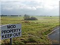
- Clicking on the map will re-center to the selected point.
- The higher the marker number, the further away the image location is from the centre of the postcode.
Image Listing (6 Images Found)
Images are licensed for reuse under creativecommons.org/licenses/by-sa/2.0
Image
Details
Distance
3
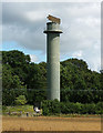
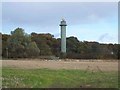
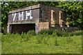
Radar tower near Acton Reynald
I am taking my lead from Geoff Pick (Image]) as to the purpose of this tower. Some of the surrounding area looks as if buildings have been demolished, but RAF Shawbury is still a functioning airfield.
Due to cutbacks, the tower is now guarded by a solitary cow.
Image: © Stephen Richards
Taken: Unknown
0.16 miles
4
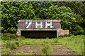
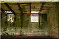
WWII Shropshire, RAF Shawbury - Aircraft Shooting-in butts (1)
-
Gun Testing Butts: EDoB ID: e11098
Used for aligning aircraft wing mounted guns.
Image
Image: © Mike Searle
Taken: 22 Jun 2019
0.19 miles
5
WWII Shropshire, RAF Shawbury - Aircraft Shooting-in Butts (3)
-
Gun Testing Butts: EDoB ID: e11098
Used for aligning aircraft wing mounted guns.
Image
Image: © Mike Searle
Taken: 22 Jun 2019
0.19 miles
6
WWII Shropshire, RAF Shawbury - Aircraft Shooting-in Butts (2)
-
Gun Testing Butts: EDoB ID: e11098
Used for aligning aircraft wing mounted guns.
Image
Image: © Mike Searle
Taken: 22 Jun 2019
0.19 miles