IMAGES TAKEN NEAR TO
Lower Road, SHREWSBURY, SY4 3QS
Introduction
This page details the photographs taken nearby to Lower Road, SY4 3QS by members of the Geograph project.
The Geograph project started in 2005 with the aim of publishing, organising and preserving representative images for every square kilometre of Great Britain, Ireland and the Isle of Man.

There are currently over 7.5m images from over14,400 individuals and you can help contribute to the project by visiting https://www.geograph.org.uk
Image Map
Images are licensed for reuse under creativecommons.org/licenses/by-sa/2.0
Notes
- Clicking on the map will re-center to the selected point.
- The higher the marker number, the further away the image location is from the centre of the postcode.
Image Listing (35 Images Found)
Images are licensed for reuse under creativecommons.org/licenses/by-sa/2.0
Image
Details
Distance
1
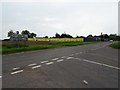
Road junction and building land at Myddle
A road junction on the A528 to the south of the village of Myddle. The light is not good in this picture due to an approaching thunderstorm, however it is recording land which about to be built on. The ground behind the hoarding is being prepared for building.
Image: © Philip Halling
Taken: 1 Jun 2018
0.04 miles
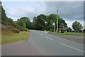
2
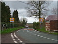
Entering Myddle
Steep hill down into the village.
Image: © JThomas
Taken: 14 Mar 2019
0.05 miles
3
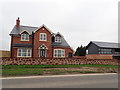
Hillcrest View, Myddle
A new housing development in the village of Myddle, near Shrewsbury.
Image: © Eirian Evans
Taken: 7 Apr 2019
0.05 miles
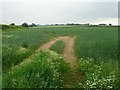
4
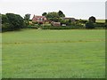
Houses on the hill
View from the public footpath across the fields towards the Low Road. Note the course of the stream running left to right in the middle of the field.
The house on the left has a remarkable series of stepped gables on the sheds.
Image: © Ian Paterson
Taken: 8 Jul 2010
0.08 miles
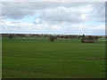
5
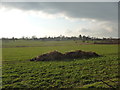
Fields near Castle Farm, Myddle
The muck heap is steaming gently in the freezing wintry air, awaiting redistribution in the coming spring no doubt. Myddle church tower is visible on the skyline.
Image: © Jeremy Bolwell
Taken: 2 Feb 2012
0.09 miles
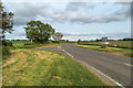
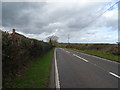
7
The Hill out of Myddle
The road leading up the hill to the A528.
Image: © David Dixon
Taken: 2 Jun 2019
0.11 miles
8
A wheat field at Myddle
A wheat field beside the A528 at Myddle.
Image: © Philip Halling
Taken: 1 Jun 2018
0.15 miles
9
A528, Myddle Hill
Looking north west toward the descent.
Image: © JThomas
Taken: 14 Mar 2019
0.15 miles
10
Winter cereal crop, Myddle Hill
A small pond in the distance.
Image: © JThomas
Taken: 14 Mar 2019
0.16 miles