IMAGES TAKEN NEAR TO
The Mount, SHREWSBURY, SY4 3LH
Introduction
This page details the photographs taken nearby to The Mount, SY4 3LH by members of the Geograph project.
The Geograph project started in 2005 with the aim of publishing, organising and preserving representative images for every square kilometre of Great Britain, Ireland and the Isle of Man.

There are currently over 7.5m images from over14,400 individuals and you can help contribute to the project by visiting https://www.geograph.org.uk
Image Map
Images are licensed for reuse under creativecommons.org/licenses/by-sa/2.0
Notes
- Clicking on the map will re-center to the selected point.
- The higher the marker number, the further away the image location is from the centre of the postcode.
Image Listing (22 Images Found)
Images are licensed for reuse under creativecommons.org/licenses/by-sa/2.0
Image
Details
Distance
1
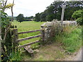
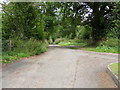
Grinshill pathway
Public footpath short cut across the corner of a field to Grinshill's country lane thoroughfare.
Image: © J Scott
Taken: 15 Jul 2011
0.02 miles
2
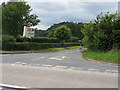
Grinshill Junction
The country lane leading from the A49 to the Inn at Grinshill.
Image: © J Scott
Taken: 15 Jul 2011
0.04 miles
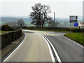
3
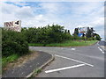
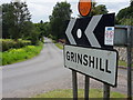
Grinshill Turn
The junction leading to Grinshill from the A49.
Image: © J Scott
Taken: 15 Jul 2011
0.04 miles
4
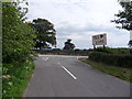
The Inn
Country lane from Grinshill joining the A49.
Image: © J Scott
Taken: 15 Jul 2011
0.04 miles
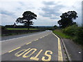
5
Turn Inn
Turning off the A49 leading to the Inn at Grinshill.
Image: © J Scott
Taken: 15 Jul 2011
0.04 miles
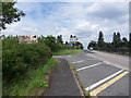
7
Grinshill Stop
Bus stop along the A49 adjacent road junction to Grinshill.
Image: © J Scott
Taken: 15 Jul 2011
0.04 miles
8
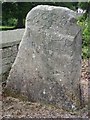
Grinshill stone
Grinshill's Millennium stone alongside country lane close to junction with the A49.
Image: © J Scott
Taken: 15 Jul 2011
0.04 miles
9
Grinshill way
Grinshill's main thoroughfare.
Image: © J Scott
Taken: 15 Jul 2011
0.07 miles
10
Grinshill Bridleway
Bridleway at the bend of Grinshill's country lane thoroughfare leading from the 49. The Bridleway leads to Birch Coppice, part of Corbet Wood.
Image: © J Scott
Taken: 15 Jul 2011
0.08 miles