IMAGES TAKEN NEAR TO
Station Road, SHREWSBURY, SY4 3LD
Introduction
This page details the photographs taken nearby to Station Road, SY4 3LD by members of the Geograph project.
The Geograph project started in 2005 with the aim of publishing, organising and preserving representative images for every square kilometre of Great Britain, Ireland and the Isle of Man.

There are currently over 7.5m images from over14,400 individuals and you can help contribute to the project by visiting https://www.geograph.org.uk
Image Map
Images are licensed for reuse under creativecommons.org/licenses/by-sa/2.0
Notes
- Clicking on the map will re-center to the selected point.
- The higher the marker number, the further away the image location is from the centre of the postcode.
Image Listing (19 Images Found)
Images are licensed for reuse under creativecommons.org/licenses/by-sa/2.0
Image
Details
Distance
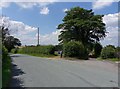
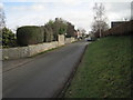
1
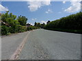
Road to Clive
Station Road leading East into the village of Clive.
Image: © J Scott
Taken: 14 Jul 2011
0.02 miles
5
Station Road
Station Road at junction with track to Sewage works,Clive
Image: © J Scott
Taken: 14 Jul 2011
0.07 miles
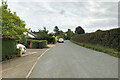
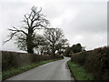
6
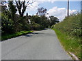
Road to station
Station Road leading to Yorton railway station, Clive.
Image: © J Scott
Taken: 14 Jul 2011
0.09 miles
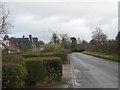
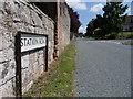
7
Station Road and stone marker, Clive
Image: © Nigel Thompson
Taken: 28 Feb 2015
0.09 miles
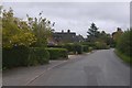
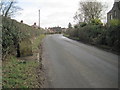
8
Station Road
Station Road opposite junction to Field Drive, Clive.
Image: © J Scott
Taken: 14 Jul 2011
0.10 miles
10
Trees profiled against a winter sky
In Station Road, Clive.
Image: © John H Darch
Taken: 3 Dec 2018
0.16 miles