IMAGES TAKEN NEAR TO
Field Drive, SHREWSBURY, SY4 3LB
Introduction
This page details the photographs taken nearby to Field Drive, SY4 3LB by members of the Geograph project.
The Geograph project started in 2005 with the aim of publishing, organising and preserving representative images for every square kilometre of Great Britain, Ireland and the Isle of Man.

There are currently over 7.5m images from over14,400 individuals and you can help contribute to the project by visiting https://www.geograph.org.uk
Image Map
Images are licensed for reuse under creativecommons.org/licenses/by-sa/2.0
Notes
- Clicking on the map will re-center to the selected point.
- The higher the marker number, the further away the image location is from the centre of the postcode.
Image Listing (59 Images Found)
Images are licensed for reuse under creativecommons.org/licenses/by-sa/2.0
Image
Details
Distance
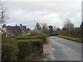
1
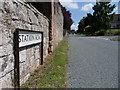
Station Road
Station Road opposite junction to Field Drive, Clive.
Image: © J Scott
Taken: 14 Jul 2011
0.03 miles
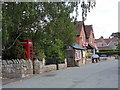
3
Back Lane
Back Lane meets the High Street, Clive.
Image: © J Scott
Taken: 14 Jul 2011
0.08 miles
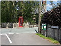
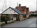
4
Post Office
General Store and Post Office, High Street, Clive.
Image: © J Scott
Taken: 14 Jul 2011
0.08 miles
5
High Street
General Store and Post Office, High Street, Clive.
Image: © J Scott
Taken: 14 Jul 2011
0.09 miles
7
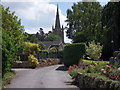
Back Lane view
All Saints viewed from Back Lane, Clive.
Image: © J Scott
Taken: 14 Jul 2011
0.10 miles
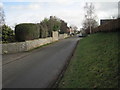
8
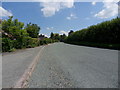
Road to Clive
Station Road leading East into the village of Clive.
Image: © J Scott
Taken: 14 Jul 2011
0.11 miles
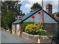
10
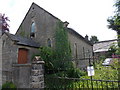
Primitive Chapel
Primitive Methodist Chapel, High Street, Clive. Disused, soon to be converted to a residential property.
Image: © J Scott
Taken: 14 Jul 2011
0.12 miles