IMAGES TAKEN NEAR TO
Orchard Fields, SHREWSBURY, SY4 3JQ
Introduction
This page details the photographs taken nearby to Orchard Fields, SY4 3JQ by members of the Geograph project.
The Geograph project started in 2005 with the aim of publishing, organising and preserving representative images for every square kilometre of Great Britain, Ireland and the Isle of Man.

There are currently over 7.5m images from over14,400 individuals and you can help contribute to the project by visiting https://www.geograph.org.uk
Image Map
Images are licensed for reuse under creativecommons.org/licenses/by-sa/2.0
Notes
- Clicking on the map will re-center to the selected point.
- The higher the marker number, the further away the image location is from the centre of the postcode.
Image Listing (6 Images Found)
Images are licensed for reuse under creativecommons.org/licenses/by-sa/2.0
Image
Details
Distance
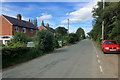
1
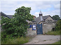
High Street, Clive
The junction of High Street and Wem Road at Clive.
Image: © David Dixon
Taken: 31 May 2019
0.19 miles
2
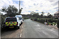
Clive
Clive is a small village in Shropshire.
Image: © David Dixon
Taken: 31 May 2019
0.19 miles
3
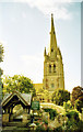
Clive Church
This beautiful church spire dominates the edge of Grinshill and is a landmark for many miles. Shropshire has many church spires but to me this ones the best...!
Image: © David Neale
Taken: 1 Aug 2004
0.21 miles
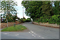
5
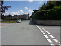
Drawell Junction
High Street meets the Drawell junction, Clive.
Image: © J Scott
Taken: 14 Jul 2011
0.22 miles