IMAGES TAKEN NEAR TO
Clive, SHREWSBURY, SY4 3JP
Introduction
This page details the photographs taken nearby to SY4 3JP by members of the Geograph project.
The Geograph project started in 2005 with the aim of publishing, organising and preserving representative images for every square kilometre of Great Britain, Ireland and the Isle of Man.

There are currently over 7.5m images from over14,400 individuals and you can help contribute to the project by visiting https://www.geograph.org.uk
Image Map
Images are licensed for reuse under creativecommons.org/licenses/by-sa/2.0
Notes
- Clicking on the map will re-center to the selected point.
- The higher the marker number, the further away the image location is from the centre of the postcode.
Image Listing (7 Images Found)
Images are licensed for reuse under creativecommons.org/licenses/by-sa/2.0
Image
Details
Distance
4
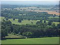
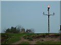
Sansaw Road
Turning off Grinshill High Street towards Sansaw viewed from the summit of Grinshill Hill.
Image: © J Scott
Taken: 14 Jul 2011
0.16 miles
5

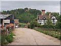
Road junction
A road junction west of Grinshill, with Grinshill Hill to the right in the distance
Image: © Alexander P Kapp
Taken: 16 Oct 2007
0.17 miles
6
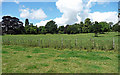
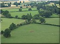
Parkland near Grinshill (1)
On the Sansaw estate.
Image: © Stephen Richards
Taken: Unknown
0.19 miles