IMAGES TAKEN NEAR TO
Yorton, SHREWSBURY, SY4 3ER
Introduction
This page details the photographs taken nearby to SY4 3ER by members of the Geograph project.
The Geograph project started in 2005 with the aim of publishing, organising and preserving representative images for every square kilometre of Great Britain, Ireland and the Isle of Man.

There are currently over 7.5m images from over14,400 individuals and you can help contribute to the project by visiting https://www.geograph.org.uk
Image Map
Images are licensed for reuse under creativecommons.org/licenses/by-sa/2.0
Notes
- Clicking on the map will re-center to the selected point.
- The higher the marker number, the further away the image location is from the centre of the postcode.
Image Listing (20 Images Found)
Images are licensed for reuse under creativecommons.org/licenses/by-sa/2.0
Image
Details
Distance
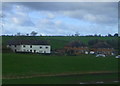
2
Beet field, Yorton
Sugar beet growing amongst unlifted silage bales. Below Yorton Station.
Image: © Richard Webb
Taken: 11 Oct 2017
0.06 miles
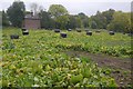
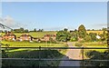
3
Farmland & cloudscape west of Yorton Station
Image: © Colin Park
Taken: 27 Sep 2020
0.09 miles
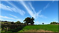
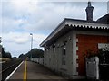
4
Yorton railway station, Shropshire
Opened in 1858 on the London & North Western Railway's line from Crewe to Shrewsbury.
View south east towards Hadnall and Shrewsbury.
Image: © Nigel Thompson
Taken: 28 Feb 2015
0.09 miles

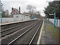
6
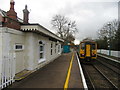
Yorton Station
Train for Shrewsbury leaves the southbound platform.
Image: © John H Darch
Taken: 3 Dec 2018
0.10 miles
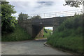
10
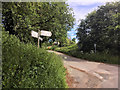
Yorton, Wayside
Minor road junction at Yorton.
Image: © David Dixon
Taken: 31 May 2019
0.11 miles