IMAGES TAKEN NEAR TO
Robert Jones Way, SHREWSBURY, SY4 3EQ
Introduction
This page details the photographs taken nearby to Robert Jones Way, SY4 3EQ by members of the Geograph project.
The Geograph project started in 2005 with the aim of publishing, organising and preserving representative images for every square kilometre of Great Britain, Ireland and the Isle of Man.

There are currently over 7.5m images from over14,400 individuals and you can help contribute to the project by visiting https://www.geograph.org.uk
Image Map
Images are licensed for reuse under creativecommons.org/licenses/by-sa/2.0
Notes
- Clicking on the map will re-center to the selected point.
- The higher the marker number, the further away the image location is from the centre of the postcode.
Image Listing (24 Images Found)
Images are licensed for reuse under creativecommons.org/licenses/by-sa/2.0
Image
Details
Distance
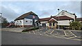

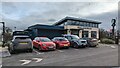
5
Burger King Car Park at Battlefield Services, North Shrewsbury
Image: © Richard Cooke
Taken: 4 Oct 2021
0.05 miles
6
Starbucks Coffee at Battlefield Services
Image: © Andrew Abbott
Taken: 3 Feb 2023
0.06 miles
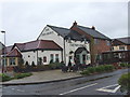
7
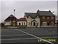
The Two Henry's
Recently opened next to the site of the new Cattle Market
Image: © Mr M Evison
Taken: 19 Mar 2006
0.09 miles
8
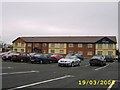
Travel Lodge
Opened recently next to the site of Shrewsbury's new Cattle Market
Image: © Mr M Evison
Taken: 19 Mar 2006
0.09 miles
9
Shrewsbury livestock market
The second new site for the market to the north of Shrewsbury.
Image: © Richard Webb
Taken: 3 Apr 2015
0.09 miles
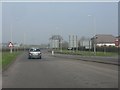
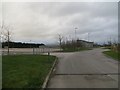
10
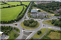
Battlefield Roundabout
Major roundabout, built in 1998, on the northern outskirts of Shrewsbury, where the A49 meets the A53 and the A5124 link road. A new ALDI store (opened in 2023) is visible adjacent to the roundabout. The provision for cyclists is there, but the cycle lane around the roundabout appears to be poorly thought through. Photo taken at 08:40 when traffic on the A49 towards the top of the image is regularly congested.
The field to the east of the A49 (to the middle-top-left of the photo) is being promoted by Andrew Dixon & Co as "employment land for industrial use for inclusion in the Local Plan" subject to Planning Permission - see https://web.archive.org/web/20230712093321/https://www.andrew-dixon.co.uk/propertyInfo.asp?id=793&catId=5&selproperty=5&minSize=-500&maxSize=10000499
Image: © TCExplorer
Taken: 12 Jul 2023
0.10 miles