IMAGES TAKEN NEAR TO
Fenemere, Baschurch, SHREWSBURY, SY4 2JD
Introduction
This page details the photographs taken nearby to SY4 2JD by members of the Geograph project.
The Geograph project started in 2005 with the aim of publishing, organising and preserving representative images for every square kilometre of Great Britain, Ireland and the Isle of Man.

There are currently over 7.5m images from over14,400 individuals and you can help contribute to the project by visiting https://www.geograph.org.uk
Image Map
Images are licensed for reuse under creativecommons.org/licenses/by-sa/2.0
Notes
- Clicking on the map will re-center to the selected point.
- The higher the marker number, the further away the image location is from the centre of the postcode.
Image Listing (3 Images Found)
Images are licensed for reuse under creativecommons.org/licenses/by-sa/2.0
Image
Details
Distance
3
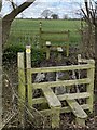
Footpath bridge by The Hayes Farm
Good stiles and signage, but the footpath then leads through an arable field which will be inpassable in a month’s time - unless the farmer clears an appropriate way across. Many of the fields in this location are similar.
Image: © Andrew Shannon
Taken: 31 Mar 2022
0.24 miles