IMAGES TAKEN NEAR TO
Stanwardine, Baschurch, SHREWSBURY, SY4 2HD
Introduction
This page details the photographs taken nearby to SY4 2HD by members of the Geograph project.
The Geograph project started in 2005 with the aim of publishing, organising and preserving representative images for every square kilometre of Great Britain, Ireland and the Isle of Man.

There are currently over 7.5m images from over14,400 individuals and you can help contribute to the project by visiting https://www.geograph.org.uk
Image Map
Images are licensed for reuse under creativecommons.org/licenses/by-sa/2.0
Notes
- Clicking on the map will re-center to the selected point.
- The higher the marker number, the further away the image location is from the centre of the postcode.
Image Listing (12 Images Found)
Images are licensed for reuse under creativecommons.org/licenses/by-sa/2.0
Image
Details
Distance
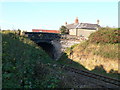
2
The railway at Stanwardine
Taken from the bridge at Stanwardine, looking south-east. This is the Shrewsbury to Wrexham line.
Image: © Eirian Evans
Taken: 23 Oct 2007
0.05 miles
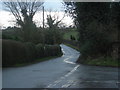
3
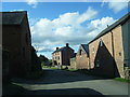
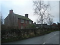
Road at Stanwardine-in-the-Fields
Looking north-westward.
Image: © Peter Wood
Taken: 3 Dec 2016
0.05 miles
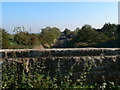
6
Railway bridge at Stanwardine in the Fields
Image: © Eirian Evans
Taken: 23 Oct 2007
0.06 miles
7
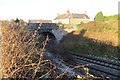
Railway bridge, Stanwardine
The railway between Shrewsbury and Chester (once the GWR route from London to Birkenhead).
Image: © Richard Webb
Taken: 28 Dec 2014
0.07 miles
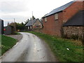
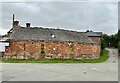
10
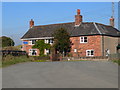
House by the railway bridge, Stanwardine
Image: © Eirian Evans
Taken: 23 Oct 2007
0.08 miles