IMAGES TAKEN NEAR TO
All Saints Way, SHREWSBURY, SY4 2FE
Introduction
This page details the photographs taken nearby to All Saints Way, SY4 2FE by members of the Geograph project.
The Geograph project started in 2005 with the aim of publishing, organising and preserving representative images for every square kilometre of Great Britain, Ireland and the Isle of Man.

There are currently over 7.5m images from over14,400 individuals and you can help contribute to the project by visiting https://www.geograph.org.uk
Image Map
Images are licensed for reuse under creativecommons.org/licenses/by-sa/2.0
Notes
- Clicking on the map will re-center to the selected point.
- The higher the marker number, the further away the image location is from the centre of the postcode.
Image Listing (7 Images Found)
Images are licensed for reuse under creativecommons.org/licenses/by-sa/2.0
Image
Details
Distance
1
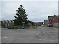
T-junction at Prescott near Baschurch
Nice sign.
Image: © Jeremy Bolwell
Taken: 24 Nov 2021
0.06 miles
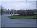
2
B5067, Prescott
The southern end of Baschurch. Prescott was once separate from Baschurch, the land between has been infilled.
Image: © Richard Webb
Taken: 16 Feb 2015
0.11 miles
3
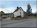
Old cottage beside the road
A nice unique home to own.
Image: © Jeremy Bolwell
Taken: 24 Nov 2021
0.18 miles
4
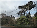
Large Lebanese Cedar tree beside the road
What a beauty. It has suffered a limb drop I think.
Image: © Jeremy Bolwell
Taken: 24 Nov 2021
0.19 miles
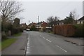
5
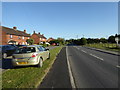
Part of Shrewsbury Road in Baschurch
Homes set back from the main road a touch.
Image: © Jeremy Bolwell
Taken: 17 Jun 2017
0.22 miles
7
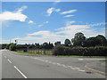
Junction of Nobold and Shrewsbury Road
Looking towards Shrewsbury
Image: © John Firth
Taken: 25 Jul 2011
0.25 miles