IMAGES TAKEN NEAR TO
Weston Road, SHREWSBURY, SY4 2DE
Introduction
This page details the photographs taken nearby to Weston Road, SY4 2DE by members of the Geograph project.
The Geograph project started in 2005 with the aim of publishing, organising and preserving representative images for every square kilometre of Great Britain, Ireland and the Isle of Man.

There are currently over 7.5m images from over14,400 individuals and you can help contribute to the project by visiting https://www.geograph.org.uk
Image Map
Images are licensed for reuse under creativecommons.org/licenses/by-sa/2.0
Notes
- Clicking on the map will re-center to the selected point.
- The higher the marker number, the further away the image location is from the centre of the postcode.
Image Listing (6 Images Found)
Images are licensed for reuse under creativecommons.org/licenses/by-sa/2.0
Image
Details
Distance
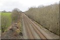
1
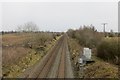
Shrewsbury to Chester railway
Passing Baschurch.
Image: © Richard Webb
Taken: 16 Feb 2015
0.15 miles
2
Bridge, Baschurch
Sandstone bridge over the Shrewsbury to Chester railway.
Image: © Richard Webb
Taken: 16 Feb 2015
0.17 miles
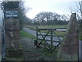
3
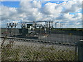
Electricity Substation
Near to Baschurch.
Image: © Eirian Evans
Taken: 26 Sep 2007
0.18 miles
4
Shrewsbury to Chester railway
Northwestward view from near Baschurch.
Image: © Richard Webb
Taken: 16 Feb 2015
0.19 miles
5
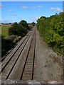
Railroad between Baschurch and Weston Lullingfields
The Shrewsbury to Wrexham line - the "Heart of Wales" operated by Arriva Trains Wales.
Image: © Eirian Evans
Taken: 26 Sep 2007
0.20 miles