IMAGES TAKEN NEAR TO
Marton Road, SHREWSBURY, SY4 2BW
Introduction
This page details the photographs taken nearby to Marton Road, SY4 2BW by members of the Geograph project.
The Geograph project started in 2005 with the aim of publishing, organising and preserving representative images for every square kilometre of Great Britain, Ireland and the Isle of Man.

There are currently over 7.5m images from over14,400 individuals and you can help contribute to the project by visiting https://www.geograph.org.uk
Image Map
Images are licensed for reuse under creativecommons.org/licenses/by-sa/2.0
Notes
- Clicking on the map will re-center to the selected point.
- The higher the marker number, the further away the image location is from the centre of the postcode.
Image Listing (7 Images Found)
Images are licensed for reuse under creativecommons.org/licenses/by-sa/2.0
Image
Details
Distance
1

Baschurch Station
View SE, towards Shrewsbury; ex-GWR Shrewsbury - Chester main line. Station closed to passengers 12/9/60, to goods 5/7/65. The closed station appears to be lived-in.
Image: © Ben Brooksbank
Taken: 24 Apr 1962
0.04 miles

4

Baschurch fire station
Baschurch fire station, Station Road, Baschurch, Shropshire
Image: © Kevin Hale
Taken: 29 Oct 2007
0.10 miles

6
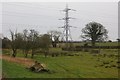
Grassland, Birchgrove
A field amongst the meres.
Image: © Richard Webb
Taken: 16 Feb 2015
0.22 miles
