IMAGES TAKEN NEAR TO
Eyton Lane, SHREWSBURY, SY4 2AU
Introduction
This page details the photographs taken nearby to Eyton Lane, SY4 2AU by members of the Geograph project.
The Geograph project started in 2005 with the aim of publishing, organising and preserving representative images for every square kilometre of Great Britain, Ireland and the Isle of Man.

There are currently over 7.5m images from over14,400 individuals and you can help contribute to the project by visiting https://www.geograph.org.uk
Image Map
Images are licensed for reuse under creativecommons.org/licenses/by-sa/2.0
Notes
- Clicking on the map will re-center to the selected point.
- The higher the marker number, the further away the image location is from the centre of the postcode.
Image Listing (5 Images Found)
Images are licensed for reuse under creativecommons.org/licenses/by-sa/2.0
Image
Details
Distance
1
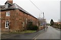
Eyton Lane, Baschurch
Passing a fine sandstone building which appears to be connected to a school. This is Newtown, which was once separate from Baschurch.
Image: © Richard Webb
Taken: 16 Feb 2015
0.05 miles
2
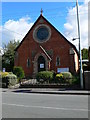
Baschurch Methodist Church
Baschurch Methodist Church was built in 1873 as a Wesley Chapel and has changed very little since. It retains many of its original features including some very attractive stained glass windows. Situated on the B5067.
Image: © Eirian Evans
Taken: 26 Sep 2007
0.09 miles
3
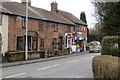
Baschurch post office
Newtown, Baschurch.
Image: © Richard Webb
Taken: 16 Feb 2015
0.10 miles
4
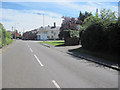
Baschurch cross roads from B4397 eastbound
Image: © John Firth
Taken: 25 Jul 2011
0.13 miles
5
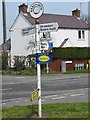
Old Direction Sign - Signpost by the B4397, Newtown, Baschurch
Annulus finial - 3 arms; Shropshire CC modern halo, by the B4397 junction with the B5067, in parish of Baschurch (North Shropshire District), Newtown, Baschurch.
Surveyed
Milestone Society National ID: SA_SJ4222
Image: © Milestone Society
Taken: Unknown
0.13 miles