IMAGES TAKEN NEAR TO
Weston Lullingfields, SHREWSBURY, SY4 2AH
Introduction
This page details the photographs taken nearby to SY4 2AH by members of the Geograph project.
The Geograph project started in 2005 with the aim of publishing, organising and preserving representative images for every square kilometre of Great Britain, Ireland and the Isle of Man.

There are currently over 7.5m images from over14,400 individuals and you can help contribute to the project by visiting https://www.geograph.org.uk
Image Map
Images are licensed for reuse under creativecommons.org/licenses/by-sa/2.0
Notes
- Clicking on the map will re-center to the selected point.
- The higher the marker number, the further away the image location is from the centre of the postcode.
Image Listing (5 Images Found)
Images are licensed for reuse under creativecommons.org/licenses/by-sa/2.0
Image
Details
Distance
1
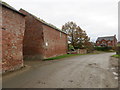
Road at the entrance to Nil Green Farm
Looking south-eastward.
Image: © Peter Wood
Taken: 3 Dec 2016
0.04 miles
2
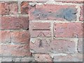
Ordnance Survey Cut Mark
This can be found on a roadside wall at Nil Green Farm.
For more detail see : http://www.bench-marks.org.uk/bm81041
Image: © Peter Wood
Taken: 3 Dec 2016
0.06 miles
4
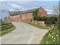
Nil Green Farm buildings
This dairy farm has a good selection of modern and traditional buildings. From this side it's mainly traditional brick built barns.
Image: © John Haynes
Taken: 11 Dec 2007
0.10 miles
5
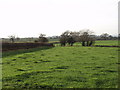
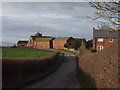
Dairy cow grazings at Nil Green Farm
At this time of the year the cows are housed which gives the grass a chance to recover.
Image: © John Haynes
Taken: 11 Dec 2007
0.20 miles