IMAGES TAKEN NEAR TO
Stapleton Road, SHREWSBURY, SY3 9LT
Introduction
This page details the photographs taken nearby to Stapleton Road, SY3 9LT by members of the Geograph project.
The Geograph project started in 2005 with the aim of publishing, organising and preserving representative images for every square kilometre of Great Britain, Ireland and the Isle of Man.

There are currently over 7.5m images from over14,400 individuals and you can help contribute to the project by visiting https://www.geograph.org.uk
Image Map
Images are licensed for reuse under creativecommons.org/licenses/by-sa/2.0
Notes
- Clicking on the map will re-center to the selected point.
- The higher the marker number, the further away the image location is from the centre of the postcode.
Image Listing (119 Images Found)
Images are licensed for reuse under creativecommons.org/licenses/by-sa/2.0
Image
Details
Distance
1
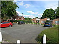
Residents' parking area at the end of Knolls Farm Close
Knolls was the small farm that previously managed this area before the Meole Brace estate was built. The farmhouse survived the developments, and is visible on the left, above the black car.
Image: © Richard Law
Taken: 5 May 2024
0.06 miles
2
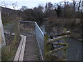
High walkway above the Rea Brook
The footpath climbs high above the watercourse at this point.
Image: © Jeremy Bolwell
Taken: 13 Feb 2021
0.08 miles
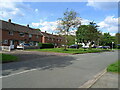
3
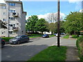
Stapleton Road, Meole Brace estate
Low-rise flats and apartments on the Meole Brace estate
Image: © Richard Law
Taken: 5 May 2024
0.08 miles
4
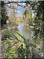
Rea Brook Valley at the back of the Meole Estate, Shrewsbury
Lovely nature reserve within yards of heavy traffic and extensive residential buildings. What a beautiful wild space to escape the everyday hurly burly. Well done Shrewsbury Town Council for managing and maintaining these green spaces around Shrewsbury.
Image: © Andrew Shannon
Taken: 10 Mar 2022
0.10 miles
5
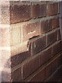
OS benchmark - Meole Brace, 122 Moneybrook Way
An OS cutmark on the side wall of 122 Moneybrook Way; originally levelled at 66.763m above Ordnance Datum Newlyn.
Image: © Richard Law
Taken: 23 Aug 2016
0.10 miles
6
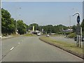
A5112 approaching Meole Brace retail park roundabout
Image: © Peter Whatley
Taken: 6 Jul 2013
0.11 miles
7
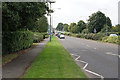
Hereford Road
The A5112 heading away from Shrewsbury. This used to be the A49 before it was diverted around the town.
Image: © Bill Boaden
Taken: 24 Aug 2018
0.12 miles

10
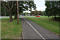
Cycle path at Meole Brace
The Meole Brace Roundabout can be seen ahead.
Image: © Bill Boaden
Taken: 24 Aug 2018
0.15 miles