IMAGES TAKEN NEAR TO
Lady Herbert Way, SHREWSBURY, SY3 9DY
Introduction
This page details the photographs taken nearby to Lady Herbert Way, SY3 9DY by members of the Geograph project.
The Geograph project started in 2005 with the aim of publishing, organising and preserving representative images for every square kilometre of Great Britain, Ireland and the Isle of Man.

There are currently over 7.5m images from over14,400 individuals and you can help contribute to the project by visiting https://www.geograph.org.uk
Image Map
Images are licensed for reuse under creativecommons.org/licenses/by-sa/2.0
Notes
- Clicking on the map will re-center to the selected point.
- The higher the marker number, the further away the image location is from the centre of the postcode.
Image Listing (9 Images Found)
Images are licensed for reuse under creativecommons.org/licenses/by-sa/2.0
Image
Details
Distance
1
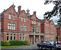
College, Radbrook Road, Shrewsbury
Built as a domestic science college for girls in 1898-1900 by C.R. Dalgleish.
At the time it was occupied by Shrewsbury College, but it moved in 2014 and this site is scheduled for redevelopment as private housing.
Image: © Stephen Richards
Taken: 13 May 2014
0.03 miles
2
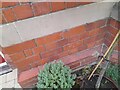
Ordnance Survey Cut Mark
This OS cut mark can be found on the Lodge at Radbrook College. It marks a point 74.862m above mean sea level.
Image: © Adrian Dust
Taken: 3 Jul 2023
0.07 miles
3
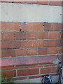
OS benchmark - Meole Brace, lodge at Radbrook College entrance
An OS cutmark on the front wall of the lodge at the entrance to the Radbrook College; originally levelled at 74.862m above Ordnance Datum Newlyn.
Image: © Richard Law
Taken: 5 May 2017
0.08 miles
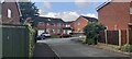

6
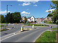
Roundabout on Hanwood Road
At the junction of Grange Farm Road with Hanwood Road
Image: © Richard Law
Taken: 5 May 2017
0.23 miles
7
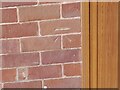
Ordnance Survey Cut Mark
This OS cut mark can be found on No41 Ridgebourne Road. It marks a point 75.148m above mean sea level.
Image: © Adrian Dust
Taken: 3 Jul 2023
0.24 miles
8
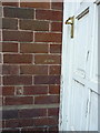
OS benchmark - Meole Brace, 41 Ridgebourne Road
An OS cutmark right outside the front door of the house; originally levelled, probably in 1967, at 75.148m above Ordnance Datum Newlyn.
Image: © Richard Law
Taken: 5 May 2017
0.24 miles
9

Autumn colours
Suburban scenery in Oakfield Road, Shrewsbury
Image: © Andrew Shannon
Taken: 13 Nov 2021
0.25 miles