IMAGES TAKEN NEAR TO
Bank Farm Road, SHREWSBURY, SY3 9DH
Introduction
This page details the photographs taken nearby to Bank Farm Road, SY3 9DH by members of the Geograph project.
The Geograph project started in 2005 with the aim of publishing, organising and preserving representative images for every square kilometre of Great Britain, Ireland and the Isle of Man.

There are currently over 7.5m images from over14,400 individuals and you can help contribute to the project by visiting https://www.geograph.org.uk
Image Map
Images are licensed for reuse under creativecommons.org/licenses/by-sa/2.0
Notes
- Clicking on the map will re-center to the selected point.
- The higher the marker number, the further away the image location is from the centre of the postcode.
Image Listing (24 Images Found)
Images are licensed for reuse under creativecommons.org/licenses/by-sa/2.0
Image
Details
Distance
1
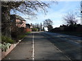
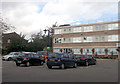
Looking up Bank Farm Road towards the back of Priory School
Image: © Marion Haworth
Taken: 19 Jan 2011
0.04 miles
2
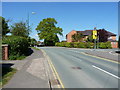
Bank Farm Road at the junction with Grange Road
Image: © Richard Law
Taken: 5 May 2017
0.05 miles
3
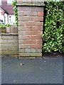
OS benchmark - Meole Brace, 55 Grange Road
An OS cutmark on a garden wall outside no 55 Grange Road; originally levelled at 82.003m above Ordnance Datum Newlyn.
Image: © Richard Law
Taken: 7 Jan 2017
0.12 miles
4
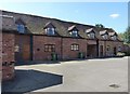
Barn conversions at Bank Farm
A late 18th century set of barns, converted to housing in recent years, but still holding a Grade II listing https://www.britishlistedbuildings.co.uk/101254916-barn-at-sj-477-110-to-south-of-bank-farm-cottages-shrewsbury#.WSZ4GOsrKM8 which was granted in 1982.
Image: © Richard Law
Taken: 5 May 2017
0.14 miles
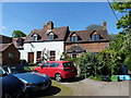
6
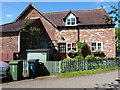
No 1 Bank Farm Cottages
Part of a Grade II listed cottage at the late 18th century Bank Farm (now converted to housing). Its listing was granted in 1982, and the details are at https://www.britishlistedbuildings.co.uk/101270556-number-1-bank-farm-cottages-and-former-stable-range-at-bank-farm-shrewsbury#.WSZ2D-srKM8
Image: © Richard Law
Taken: 5 May 2017
0.15 miles
7
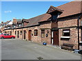
Bank Farm Stable Range
A Grade II listed, late 18th century set of former stables https://www.britishlistedbuildings.co.uk/101270556-number-1-bank-farm-cottages-and-former-stable-range-at-bank-farm-shrewsbury#.WSZ2D-srKM8
Image: © Richard Law
Taken: 5 May 2017
0.15 miles
8
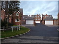
Part of Mousecroft Grange, Shrewsbury
A fairly recent development of half-a-dozen or so large detached homes in a cul-de-sac on a slope off the north side of Mousecroft Lane.
Image: © Jeremy Bolwell
Taken: 19 Jan 2012
0.16 miles
9
Bank Farm cottages
A pair of late 18th century cottages, granted a Grade II listing https://www.britishlistedbuildings.co.uk/101270518-bank-farm-cottages-shrewsbury in 1982
Image: © Richard Law
Taken: 5 May 2017
0.16 miles
10
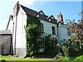
Bank Farmhouse
Part of a Grade II listed pair of late 18th century houses (the other part being the adjoining St Mary's Grange, not photographed here) the listing being granted in 1982 at https://www.britishlistedbuildings.co.uk/101254915-bank-farmhouse-and-st-marys-grange-shrewsbury#.WSZ6J-srKM8
Image: © Richard Law
Taken: 5 May 2017
0.16 miles