IMAGES TAKEN NEAR TO
Kingswood Crescent, SHREWSBURY, SY3 8UU
Introduction
This page details the photographs taken nearby to Kingswood Crescent, SY3 8UU by members of the Geograph project.
The Geograph project started in 2005 with the aim of publishing, organising and preserving representative images for every square kilometre of Great Britain, Ireland and the Isle of Man.

There are currently over 7.5m images from over14,400 individuals and you can help contribute to the project by visiting https://www.geograph.org.uk
Image Map
Images are licensed for reuse under creativecommons.org/licenses/by-sa/2.0
Notes
- Clicking on the map will re-center to the selected point.
- The higher the marker number, the further away the image location is from the centre of the postcode.
Image Listing (29 Images Found)
Images are licensed for reuse under creativecommons.org/licenses/by-sa/2.0
Image
Details
Distance
1
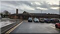
Oak House
Part of the Midwife Led Unit at the Royal Shrewsbury Hospital
Image: © Andrew Abbott
Taken: 30 Dec 2022
0.06 miles
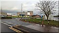
2
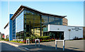
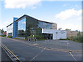
Shropshire education & conference centre
This new building is on the hospital site.
Image: © Dave Croker
Taken: 13 May 2008
0.09 miles
3
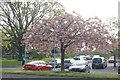
Blossom tree in Hospital grounds car park
Image: © John Firth
Taken: 8 May 2008
0.09 miles
4
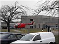
Royal Shrewsbury Hospital
Powys air ambulance coming into land. The people of Powys rely heavily upon the air ambulance service as much of the population live in isolated rural communities not speedily accessible by road. The Royal Shrewsbury is usually the nearest appropriate hospital for emergency treatment.
When the ambulance is about to land or take off the car park entrances and nearby access roads are closed - note gates on the right.
Image: © Penny Mayes
Taken: 18 Mar 2010
0.09 miles
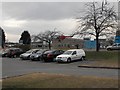
5
Royal Shrewsbury Hospital
Powys air ambulance coming into land. The people of Powys rely heavily upon the air ambulance service as much of the population live in isolated rural communities not speedily accessible by road. The Royal Shrewsbury is usually the nearest appropriate hospital for emergency treatment.
When the ambulance is about to land or take off the car park entrances and nearby access roads are closed - note gates on the right.
Image: © Penny Mayes
Taken: 18 Mar 2010
0.09 miles
6
Royal Shrewsbury Hospital
Looking towards the helipad.
Image: © Andrew Abbott
Taken: 30 Dec 2022
0.10 miles
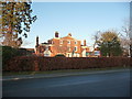
7
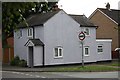
Mytton Villa, Shrewsbury
Originally built in the late 18th century, this fine house attracted a Grade II listing https://britishlistedbuildings.co.uk/101271069-mytton-villa-shrewsbury#.Y1sEa3bMLIU & https://historicengland.org.uk/listing/the-list/list-entry/1271069 in 1969. It's now the centre of a retirement complex consisting of flats in the house and a number of surrounding bungalows, having been converted in the late 1980s.
Image: © Richard Law
Taken: 21 Oct 2022
0.10 miles
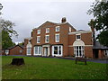
8
Mytton Hall, Shrewsbury
An old country house now divided into apartments and surrounded by the expansion of Shrewsbury's suburbs.
Image: © Jeremy Bolwell
Taken: 17 Jan 2012
0.11 miles
10
Old Toll House, Copthorne
Toll House in the parish of Shrewsbury, at the junction of Mytton Oak Road (B4386), and Crowmeole Lane, Copthorne.
Shropshire HER.
HER Number (PRN): 17201 https://www.heritagegateway.org.uk/Gateway/Results_Single.aspx?uid=MSA17866&resourceID=1015
To be surveyed
Milestone Society National ID: SA.COP
Image: © Milestone Society
Taken: Unknown
0.13 miles