IMAGES TAKEN NEAR TO
Shorncliffe Drive, SHREWSBURY, SY3 8TE
Introduction
This page details the photographs taken nearby to Shorncliffe Drive, SY3 8TE by members of the Geograph project.
The Geograph project started in 2005 with the aim of publishing, organising and preserving representative images for every square kilometre of Great Britain, Ireland and the Isle of Man.

There are currently over 7.5m images from over14,400 individuals and you can help contribute to the project by visiting https://www.geograph.org.uk
Image Map
Images are licensed for reuse under creativecommons.org/licenses/by-sa/2.0
Notes
- Clicking on the map will re-center to the selected point.
- The higher the marker number, the further away the image location is from the centre of the postcode.
Image Listing (10 Images Found)
Images are licensed for reuse under creativecommons.org/licenses/by-sa/2.0
Image
Details
Distance
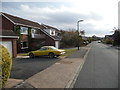
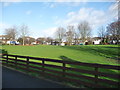
1
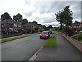
Part of Copthorne Park in Shrewsbury
A nice residential road in this popular suburb.
Image: © Jeremy Bolwell
Taken: 27 Jun 2020
0.12 miles
2
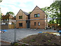
New build beside the main road
Nice place. It has been under construction for a long time, so I assume a thorough job is being done.
Image: © Jeremy Bolwell
Taken: 27 Jun 2020
0.18 miles
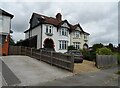
3
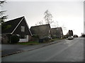
Part of Thornhill Road, Shrewsbury
1960's vintage houses on this rise. Nice.
Image: © Jeremy Bolwell
Taken: 13 Dec 2011
0.18 miles
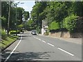
5
Part of Mossbank Way, Shelton, Shrewsbury
A Lotus Elan sets off the road perfectly.
Image: © Jeremy Bolwell
Taken: 24 Oct 2011
0.19 miles

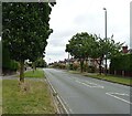
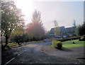
10
Part of Eastwood Road, Shrewsbury
The curved section - nice.
Image: © Jeremy Bolwell
Taken: 13 Dec 2011
0.25 miles