IMAGES TAKEN NEAR TO
Shelton Road, SHREWSBURY, SY3 8ST
Introduction
This page details the photographs taken nearby to Shelton Road, SY3 8ST by members of the Geograph project.
The Geograph project started in 2005 with the aim of publishing, organising and preserving representative images for every square kilometre of Great Britain, Ireland and the Isle of Man.

There are currently over 7.5m images from over14,400 individuals and you can help contribute to the project by visiting https://www.geograph.org.uk
Image Map
Images are licensed for reuse under creativecommons.org/licenses/by-sa/2.0
Notes
- Clicking on the map will re-center to the selected point.
- The higher the marker number, the further away the image location is from the centre of the postcode.
Image Listing (22 Images Found)
Images are licensed for reuse under creativecommons.org/licenses/by-sa/2.0
Image
Details
Distance
3
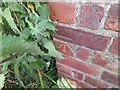
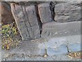
Ordnance Survey Cut Mark
This OS cut mark can be found on the building NW side of Radbrook Road . It marks a point 77.916m above mean sea level.
Image: © Adrian Dust
Taken: 3 Jul 2023
0.08 miles
4
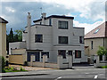
33 Shelton Road, Shrewsbury
One of the area's early C20th Modernist experiments amid more typical suburbia. Note the whiteness, flat roofs, and windows turning the corner. This is by G. Ward Deakin, 1934-35. Pevsner calls the style, "Jazz-Modern".
Image: © Stephen Richards
Taken: 13 May 2014
0.09 miles
5
Ordnance Survey Cut Mark
This OS cut mark can be found on the wall SE side of Porthill Road. It marks a point 76.283m above mean sea level.
Image: © Adrian Dust
Taken: 3 Jul 2023
0.10 miles
6
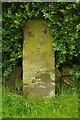
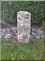
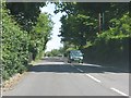
Old Milestone by the A488, Radbrook Road, Shrewsbury
Stone post (plate lost) by the A488, in parish of SHREWSBURY (SHREWSBURY AND ATCHAM District), Radbrook Road, No. 19, in hedge, South East side of road. Erected by the Shrewsbury to Minsterley turnpike trust in the 19th century.
Inscription once read:-
(Shrewsbury)
(1)
Shropshire HER listed.
HER Number (PRN): 21140 https://www.heritagegateway.org.uk/Gateway/Results_Single.aspx?uid=MSA23739&resourceID=1015
Milestone Society National ID: SA_SBBC01.
Image: © A Reade/J Higgins
Taken: 1 Jun 2006
0.10 miles
8
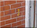
Ordnance Survey Cut Mark
This OS cut mark can be found on No1 Woodfield Avenue. It marks a point 78.315m above mean sea level.
Image: © Adrian Dust
Taken: 3 Jul 2023
0.12 miles
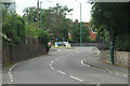
9
Woodbank Drive, Porthill, Shrewsbury
A small, select and secluded close or cul-de-sac rather than a drive but what's in a name?
Image: © Jeremy Bolwell
Taken: 30 Sep 2011
0.13 miles
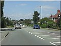
10
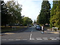
Radbrook Road north of Ridgebourne Road
Image: © Peter Whatley
Taken: 6 Jul 2013
0.14 miles