IMAGES TAKEN NEAR TO
Oakfield Drive, SHREWSBURY, SY3 8AR
Introduction
This page details the photographs taken nearby to Oakfield Drive, SY3 8AR by members of the Geograph project.
The Geograph project started in 2005 with the aim of publishing, organising and preserving representative images for every square kilometre of Great Britain, Ireland and the Isle of Man.

There are currently over 7.5m images from over14,400 individuals and you can help contribute to the project by visiting https://www.geograph.org.uk
Image Map
Images are licensed for reuse under creativecommons.org/licenses/by-sa/2.0
Notes
- Clicking on the map will re-center to the selected point.
- The higher the marker number, the further away the image location is from the centre of the postcode.
Image Listing (14 Images Found)
Images are licensed for reuse under creativecommons.org/licenses/by-sa/2.0
Image
Details
Distance
1
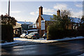
Salopian Brewery
"Salopian Brewery was established at The Old Dairy on the outskirts of mediaeval Shrewsbury in 1995." http://www.salopianbrewery.co.uk/
Image: © Mike White
Taken: 17 Dec 2010
0.09 miles
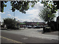
2
Salopian Brewery
Excellent brewer of Real ale.
Image: © John Firth
Taken: 1 Sep 2009
0.10 miles
3

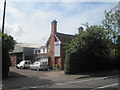
Site of Salopian Brewery
The brewery moved to Hadnall in 2014 and the old building Image has been demolished. The Salopian brewery is now located in the blue industrial unit in the background of this image: Image
Image: © Mike White
Taken: 20 Sep 2017
0.10 miles
5
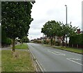
Old Toll House, Copthorne
Toll House in the parish of Shrewsbury, at the junction of Mytton Oak Road (B4386), and Crowmeole Lane, Copthorne.
Shropshire HER.
HER Number (PRN): 17201 https://www.heritagegateway.org.uk/Gateway/Results_Single.aspx?uid=MSA17866&resourceID=1015
To be surveyed
Milestone Society National ID: SA.COP
Image: © Milestone Society
Taken: Unknown
0.15 miles
8
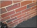
Ordnance Survey Cut Mark
This OS cut mark can be found on No38 Oakfield Road. It marks a point 77.181m above mean sea level.
Image: © Adrian Dust
Taken: 3 Jul 2023
0.22 miles
9
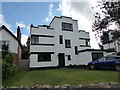
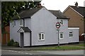
Art Deco hose on Oakfield Road, Copthorne, Shrewsbury
One of several homes built in this style to be found in this suburb.
Image: © Jeremy Bolwell
Taken: 27 Jun 2020
0.23 miles
10
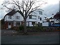
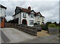
Part of Oakfield Road, Copthorne, Shrewsbury
On the kink in Oakfield Road a nice Art Deco property was built, the only property of this style in this long road. This is a good example - well maintained and looking as though it may have benefited from a revamp lately. Nice.
Image: © Jeremy Bolwell
Taken: 3 Nov 2011
0.24 miles