IMAGES TAKEN NEAR TO
Kenwood Road, SHREWSBURY, SY3 8AJ
Introduction
This page details the photographs taken nearby to Kenwood Road, SY3 8AJ by members of the Geograph project.
The Geograph project started in 2005 with the aim of publishing, organising and preserving representative images for every square kilometre of Great Britain, Ireland and the Isle of Man.

There are currently over 7.5m images from over14,400 individuals and you can help contribute to the project by visiting https://www.geograph.org.uk
Image Map
Images are licensed for reuse under creativecommons.org/licenses/by-sa/2.0
Notes
- Clicking on the map will re-center to the selected point.
- The higher the marker number, the further away the image location is from the centre of the postcode.
Image Listing (22 Images Found)
Images are licensed for reuse under creativecommons.org/licenses/by-sa/2.0
Image
Details
Distance
1
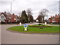
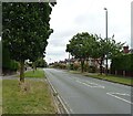
Copthorne roundabout, Shrewsbury
Until the mid-1990s the road ahead was part of the Shrewsbury bypass on the busy A5. Built in the 1930s, the land around it was heavily developed after World War 2, and it became a major bottleneck as well as a danger to pedestrians. The new dual carriageway A5 now takes a big sweep to the south of the town, and the old bypass is a relatively quiet suburban B road.
Image: © David Gruar
Taken: 2 Apr 2006
0.05 miles
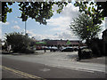
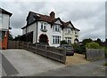
2
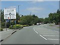
Approaching Copthorne Roundabout from the south
Image: © Peter Whatley
Taken: 6 Jul 2013
0.06 miles
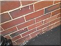
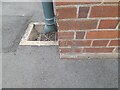
3
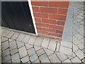
Ordnance Survey Cut Mark
This OS cut mark can be found on the garage of No2 Mytton Oak Road. It marks a point 77.732m above mean sea level.
Image: © Adrian Dust
Taken: 3 Jul 2023
0.08 miles
4
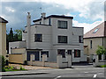
33 Shelton Road, Shrewsbury
One of the area's early C20th Modernist experiments amid more typical suburbia. Note the whiteness, flat roofs, and windows turning the corner. This is by G. Ward Deakin, 1934-35. Pevsner calls the style, "Jazz-Modern".
Image: © Stephen Richards
Taken: 13 May 2014
0.12 miles
7
Ordnance Survey Cut Mark
This OS cut mark can be found on No38 Oakfield Road. It marks a point 77.181m above mean sea level.
Image: © Adrian Dust
Taken: 3 Jul 2023
0.14 miles
10
Ordnance Survey Cut Mark
This OS cut mark can be found on The Beacon PH. It marks a point 75.824m above mean sea level.
Image: © Adrian Dust
Taken: 3 Jul 2023
0.16 miles