IMAGES TAKEN NEAR TO
Hawthorn Road, SHREWSBURY, SY3 7NB
Introduction
This page details the photographs taken nearby to Hawthorn Road, SY3 7NB by members of the Geograph project.
The Geograph project started in 2005 with the aim of publishing, organising and preserving representative images for every square kilometre of Great Britain, Ireland and the Isle of Man.

There are currently over 7.5m images from over14,400 individuals and you can help contribute to the project by visiting https://www.geograph.org.uk
Image Map
Images are licensed for reuse under creativecommons.org/licenses/by-sa/2.0
Notes
- Clicking on the map will re-center to the selected point.
- The higher the marker number, the further away the image location is from the centre of the postcode.
Image Listing (81 Images Found)
Images are licensed for reuse under creativecommons.org/licenses/by-sa/2.0
Image
Details
Distance
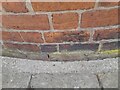
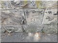
1
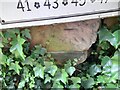
Ordnance Survey Cut Mark
This OS cut mark can be found on the SW parapet of the railway bridge. It marks a point 64.831m above mean sea level.
Image: © Adrian Dust
Taken: 4 Jul 2023
0.04 miles
2
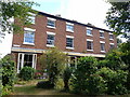
7 & 9 Havelock Road, Belle Vue
A pair of early 19th century houses, with a continuous verandah on latticed cast-iron columns across the whole frontage, which were Grade II listed https://britishlistedbuildings.co.uk/101254464-7-and-9-havelock-road-shrewsbury#.Yw-mrnbMLIU & https://historicengland.org.uk/listing/the-list/list-entry/1254464 in 1995.
Image: © Richard Law
Taken: 20 Aug 2022
0.05 miles
3
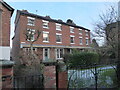
Berwick Place, Belle Vue, Shrewsbury
Lovely tall town houses.
Image: © Jeremy Bolwell
Taken: 30 Dec 2020
0.05 miles
5
Ordnance Survey Cut Mark
This OS cut mark can be found on the wall SE of Hawthorn Road. It marks a point 63.164m above mean sea level.
Image: © Adrian Dust
Taken: 4 Jul 2023
0.05 miles
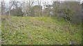
6
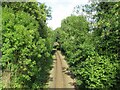
Cambrian Line approaching Shrewsbury
A view of the Cambrian Line as it approaches its terminus in Shrewsbury. The railway here is single track.
Image: © Malc McDonald
Taken: 4 Aug 2023
0.06 miles
7
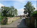
Havelock Road, Shrewsbury
A bridge carries Havelock Road across a railway line in Shrewsbury.
Image: © Malc McDonald
Taken: 4 Aug 2023
0.06 miles
8
Part of Havelock Street, Belle Vue, Shrewsbury
A very sought after residential street in the sought after suburb of Belle Vue.
Image: © Jeremy Bolwell
Taken: 30 Dec 2020
0.06 miles
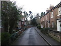
9
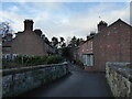
Scene on the road bridge over the railway at Havelock Road, Bellevue, Shrewsbury
Charming but narrow streets.
Image: © Jeremy Bolwell
Taken: 3 Jan 2022
0.06 miles
10
Ordnance Survey Cut Mark
This OS cut mark can be found on the SW parapet of the railway bridge. It marks a point 66.218m above mean sea level.
Image: © Adrian Dust
Taken: 4 Jul 2023
0.06 miles