IMAGES TAKEN NEAR TO
Belle Vue Road, SHREWSBURY, SY3 7LN
Introduction
This page details the photographs taken nearby to Belle Vue Road, SY3 7LN by members of the Geograph project.
The Geograph project started in 2005 with the aim of publishing, organising and preserving representative images for every square kilometre of Great Britain, Ireland and the Isle of Man.

There are currently over 7.5m images from over14,400 individuals and you can help contribute to the project by visiting https://www.geograph.org.uk
Image Map
Images are licensed for reuse under creativecommons.org/licenses/by-sa/2.0
Notes
- Clicking on the map will re-center to the selected point.
- The higher the marker number, the further away the image location is from the centre of the postcode.
Image Listing (295 Images Found)
Images are licensed for reuse under creativecommons.org/licenses/by-sa/2.0
Image
Details
Distance
3
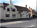
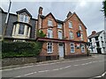
The Boar's Head, Coleham
A pub on Belle Vue Road, Shrewsbury
Image: © Richard Law
Taken: 25 Jun 2011
0.06 miles
4
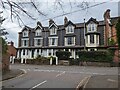
47-53 Belle Vue Road, Shrewsbury
See also Image for more info - a row of houses in blue brick built by Daniel Climie in the 1850s, the last for himself.
Image: © TCExplorer
Taken: 31 Mar 2024
0.06 miles
5
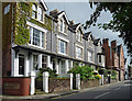
47-55 Belle Vue Road, Shrewsbury
Four houses in blue brick, built in the 1850s by Daniel Climie, the last for himself. The group terminates in the red-brick Masonic Arms pub. The colours are not accidental. "The terrace echoes the system of colour-coding he used for his railway stations between Shrewsbury and Crewe in which blue brick distinguished 'first class' establishments from the others in the cheaper red".
Image: © Stephen Richards
Taken: 13 May 2014
0.06 miles
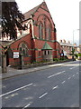
7
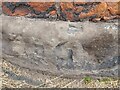
Ordnance Survey Pivot
This OS cut mark can be found on the wall at the junction of Old Coleham & Betton Street. It marks a point 53.281m above mean sea level.
Image: © Adrian Dust
Taken: 4 Jul 2023
0.07 miles
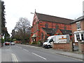
10
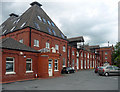
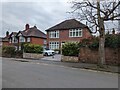
Former maltings, Belle Vue Road, Shrewsbury
Built in 1888 for William James, "who dominated Shrewsbury's considerable malt trade in the late C19".
Converted to offices in the 1990s and known at the time as Prospect House. Since this photo, it has changed hands and partial conversion to flats is on the cards.
Image: © Stephen Richards
Taken: 13 May 2014
0.08 miles