IMAGES TAKEN NEAR TO
Oakley Street, SHREWSBURY, SY3 7JZ
Introduction
This page details the photographs taken nearby to Oakley Street, SY3 7JZ by members of the Geograph project.
The Geograph project started in 2005 with the aim of publishing, organising and preserving representative images for every square kilometre of Great Britain, Ireland and the Isle of Man.

There are currently over 7.5m images from over14,400 individuals and you can help contribute to the project by visiting https://www.geograph.org.uk
Image Map
Images are licensed for reuse under creativecommons.org/licenses/by-sa/2.0
Notes
- Clicking on the map will re-center to the selected point.
- The higher the marker number, the further away the image location is from the centre of the postcode.
Image Listing (53 Images Found)
Images are licensed for reuse under creativecommons.org/licenses/by-sa/2.0
Image
Details
Distance
1
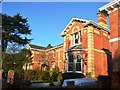
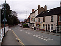
Intruder on the premises at Cleveland House
Victorian houses on Oakley Street, Belle Vue.
Image: © John M
Taken: 29 Dec 2016
0.03 miles
2
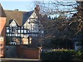
Oakley Manor
Built as his home by S Pountney Smith around 1860 and used as an Auxiliary Hospital until towards the end of the Great War when the patients were removed to larger premises at Prestfelde School, London Road. The buildings were used by Shrewsbury and Atcham Council from 1970-2000 when the council departments moved into the new Guildhall. The Manor Gardens have been developed for housing almost hiding the large Victorian building.
Image: © John M
Taken: 29 Dec 2016
0.04 miles
3
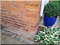
Ordnance Survey Cut Mark
This OS cut mark can be found on the wall NW side of Belle Vue Road. It marks a point 66.154m above mean sea level.
Image: © Adrian Dust
Taken: 4 Jul 2023
0.05 miles
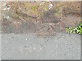
4
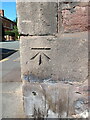
OS benchmark, Belle Vue Road
An OS cutmark on a wall on the NW side of the road at the junction with Oakley Street, which was last levelled by the OS in 1967 at 66.154m above Ordnance Datum Newlyn. However, from its style and the fact that it appears on the 1902 map (at a height of 217.2 ft above Liverpool datum) it's fair to assume it was cut as part of the First Primary Levelling survey of the country, which took place between 1840 & 1860.
Image: © Richard Law
Taken: 20 Aug 2022
0.05 miles
5
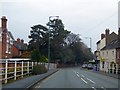
Belle Vue Road, Shrewsbury
Looking from the railway bridge towards the centre of town. This used to be the main road into town from the south, but traffic is now signed along the new A5112 and Old Potts Way.
Image: © David Gruar
Taken: 2 Apr 2006
0.05 miles
6
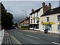
A5191 leading into Shrewsbury
The road is sloping after crossing the railway bridge. About here the road name changes to Belle Vue Road. On the right is The Grove public house
Image: © David Smith
Taken: 28 Nov 2014
0.05 miles
7
The Grove and a chippy
The Grove public house, Belle Vue Road
Image: © Richard Law
Taken: 25 Jun 2011
0.06 miles
8
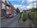
Looking up Drawwell Street towards Belle Vue Road
Image: © TCExplorer
Taken: 9 Apr 2024
0.06 miles
9
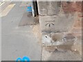
Ordnance Survey Cut Mark
This OS cut mark can be found on No7 Oak Road. It marks a point 66.290m above mean sea level.
Image: © Adrian Dust
Taken: 4 Jul 2023
0.06 miles
10
Ordnance Survey Cut Mark
This OS cut mark can be found on the east parapet of the railway bridge. It marks a point 68.510m above mean sea level.
Image: © Adrian Dust
Taken: 4 Jul 2023
0.07 miles