IMAGES TAKEN NEAR TO
Longden Road, SHREWSBURY, SY3 7HS
Introduction
This page details the photographs taken nearby to Longden Road, SY3 7HS by members of the Geograph project.
The Geograph project started in 2005 with the aim of publishing, organising and preserving representative images for every square kilometre of Great Britain, Ireland and the Isle of Man.

There are currently over 7.5m images from over14,400 individuals and you can help contribute to the project by visiting https://www.geograph.org.uk
Image Map
Images are licensed for reuse under creativecommons.org/licenses/by-sa/2.0
Notes
- Clicking on the map will re-center to the selected point.
- The higher the marker number, the further away the image location is from the centre of the postcode.
Image Listing (51 Images Found)
Images are licensed for reuse under creativecommons.org/licenses/by-sa/2.0
Image
Details
Distance
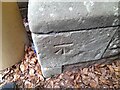
2
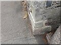
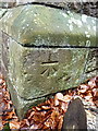
Ordnance Survey Cut Mark
This OS cut mark can be found on the cemetery wall at junction of path and Longden Road. It marks a point 73.251m above mean sea level.
Image: © Adrian Dust
Taken: 4 Jul 2023
0.02 miles
3
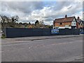
New homes construction
On the site of the former Sabrina Monumental Works, is "an exciting development of 3 individually designed luxury detached 4 & 5 bedroom family homes".
Image: © TCExplorer
Taken: 9 Apr 2024
0.02 miles
4
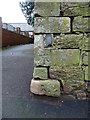
OS benchmark - Meole Brace, wall on Longden Road
An OS cutmark beside the path that runs along the northern boundary of the cemetery; originally levelled at 73.251m above Ordnance Datum Newlyn.
Image: © Richard Law
Taken: 7 Jan 2017
0.02 miles
5
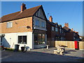
Greek Restaurant on Longden Road, Shrewsbury
Showing position of Postbox No. SY3 261.
See Image] for postbox.
Image: © JThomas
Taken: 28 Mar 2019
0.03 miles
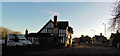
6
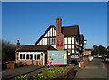
The Red Barn public house, Shrewsbury
On Longden Road.
Image: © JThomas
Taken: 28 Mar 2019
0.03 miles
7
OS benchmark - Meole Brace mortuary chapel
An OS cutmark on the small Chapel of Remembrance in the churchyard; originally levelled at 72.222m above Ordnance Datum Newlyn.
Image: © Richard Law
Taken: 7 Jan 2017
0.04 miles
8
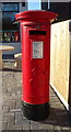
George V postbox on Longden Road, Shrewsbury
Postbox No. SY3 261.
See Image] for context.
Image: © JThomas
Taken: 28 Mar 2019
0.04 miles
9
Ordnance Survey Cut Mark
This OS cut mark can be found on the SE face of the Mortuary Chapel. It marks a point 72.222m above mean sea level.
Image: © Adrian Dust
Taken: 4 Jul 2023
0.04 miles
10
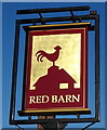
Sign for the Red Barn public house, Shrewsbury
See Image] for context.
Image: © JThomas
Taken: 28 Mar 2019
0.05 miles