IMAGES TAKEN NEAR TO
Stonehurst Drive, SHREWSBURY, SY2 6DF
Introduction
This page details the photographs taken nearby to Stonehurst Drive, SY2 6DF by members of the Geograph project.
The Geograph project started in 2005 with the aim of publishing, organising and preserving representative images for every square kilometre of Great Britain, Ireland and the Isle of Man.

There are currently over 7.5m images from over14,400 individuals and you can help contribute to the project by visiting https://www.geograph.org.uk
Image Map
Images are licensed for reuse under creativecommons.org/licenses/by-sa/2.0
Notes
- Clicking on the map will re-center to the selected point.
- The higher the marker number, the further away the image location is from the centre of the postcode.
Image Listing (37 Images Found)
Images are licensed for reuse under creativecommons.org/licenses/by-sa/2.0
Image
Details
Distance
1
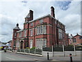
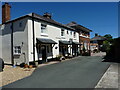
Stonehurst
A substantial Victorian or Edwardian property.
Image: © Jeremy Bolwell
Taken: 28 Jun 2020
0.02 miles

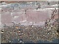
4
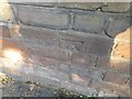
Ordnance Survey Cut Mark
This OS cut mark can be found on the wall of No8 Sutton Road. It marks a point 67.891m above mean sea level.
Image: © Adrian Dust
Taken: 4 Jul 2023
0.09 miles
5
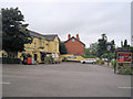
Sutton Road, Shrewsbury
Passing through an established suburb.
Image: © Richard Webb
Taken: 11 Oct 2017
0.11 miles
6
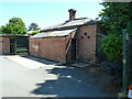
The former punishment block at The Armoury
Erected in the early 19th century as a small prison/punishment block for miscreants at the Armoury Barracks complex, but now looking a little dilapidated and in need of some TLC. Used now as a storeroom/shed for a number of the adjacent houses. It was Grade II listed https://britishlistedbuildings.co.uk/101254527-former-punishment-block-at-the-armoury-shrewsbury#.Yxuo73bMLIU & https://historicengland.org.uk/listing/the-list/list-entry/1254527 in 1972.
Image: © Richard Law
Taken: 10 Jul 2022
0.12 miles
7
Nos 7 & 10 The Armoury, Shrewsbury
Former officer's house and (probable) workshops or stabling, now converted to private housing. The whole range dates from the very early 19th century, and was erected as part of the military barracks of Shrewsbury Armoury; it was all Grade II listed https://britishlistedbuildings.co.uk/101255094-7-12-the-armoury-shrewsbury#.YxunR3bMLIU & https://historicengland.org.uk/listing/the-list/list-entry/1255094 in 1972, along with no 12 which lies just off-shot to the right.
Image: © Richard Law
Taken: 10 Jul 2022
0.13 miles
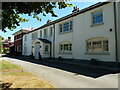
8
Nos 1 - 4 The Armoury, Shrewsbury
A range of former military buildings including one officer's house and a set of former workshops, now converted to private housing. They date from around 1806, and were Grade II listed https://britishlistedbuildings.co.uk/101254939-numbers-1-4-the-armoury-shrewsbury#.Yxuqd3bMLIU & https://historicengland.org.uk/listing/the-list/list-entry/1254939 in 1972.
Image: © Richard Law
Taken: 10 Jul 2022
0.13 miles
9
Ordnance Survey Cut Mark
This OS cut mark can be found on the wall west side of Sutton Road. It marks a point 68.940m above mean sea level.
Image: © Adrian Dust
Taken: 4 Jul 2023
0.14 miles
10
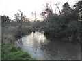
Early hazel catkins over the Reabrook in Shrewsbury
Early January in exceptionally mild weather and these harbingers of Spring are out already.
Image: © Jeremy Bolwell
Taken: 3 Jan 2022
0.14 miles