IMAGES TAKEN NEAR TO
Abbey Foregate, SHREWSBURY, SY2 6AS
Introduction
This page details the photographs taken nearby to Abbey Foregate, SY2 6AS by members of the Geograph project.
The Geograph project started in 2005 with the aim of publishing, organising and preserving representative images for every square kilometre of Great Britain, Ireland and the Isle of Man.

There are currently over 7.5m images from over14,400 individuals and you can help contribute to the project by visiting https://www.geograph.org.uk
Image Map
Images are licensed for reuse under creativecommons.org/licenses/by-sa/2.0
Notes
- Clicking on the map will re-center to the selected point.
- The higher the marker number, the further away the image location is from the centre of the postcode.
Image Listing (174 Images Found)
Images are licensed for reuse under creativecommons.org/licenses/by-sa/2.0
Image
Details
Distance
1
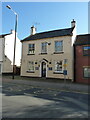
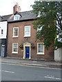
134 Abbey Foregate, Shrewsbury
Also known as Abbey Court House, this well-proportioned early 19th century house was Grade II listed https://britishlistedbuildings.co.uk/101246385-134-abbey-foregate-shrewsbury & https://historicengland.org.uk/listing/the-list/list-entry/1246385 in 1953. The owners operate a B&B business from the property.
Image: © Richard Law
Taken: 20 Apr 2023
0.01 miles
2
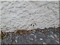
Ordnance Survey Cut Mark
This OS cut mark can be found on the wall of No110 Abbey Foregate. It marks a point 59.942m above mean sea level.
Image: © Adrian Dust
Taken: 4 Jul 2023
0.01 miles
3
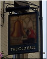
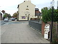
Sign for the Old Bell, Shrewsbury
See Image] for context.
Image: © JThomas
Taken: 18 May 2019
0.01 miles
4
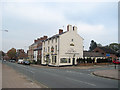
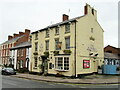
The Old Bell Shrewsbury
On corner of Abbey Foregate and Bell Lane
Image: © John Firth
Taken: 13 Oct 2010
0.02 miles
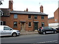
5
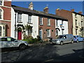
139 Abbey Foregate, Shrewsbury
A late 18th century town house, which attracted a Grade II listing https://britishlistedbuildings.co.uk/101246329-139-abbey-foregate-shrewsbury#.XWLwQehKjcs & https://historicengland.org.uk/listing/the-list/list-entry/1246329 in 1953. The listing refers to a small lean-to on the right hand side; this has now been demolished, but lay behind the white wall with the blocked window on the right of this photo.
Image: © Richard Law
Taken: 4 Jul 2019
0.02 miles
6
112, 113 & 114 Abbey Foregate, Shrewsbury
A terrace of 3 relatively plain town houses, built around 1840. They were collectively Grade II listed https://britishlistedbuildings.co.uk/101246325-112-113-and-114-abbey-foregate-shrewsbury & https://historicengland.org.uk/listing/the-list/list-entry/1246325 in 1953.
Image: © Richard Law
Taken: 20 Apr 2023
0.02 miles
7
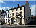
The Old Bell, Abbey Foregate, Shrewsbury
A Marston's pub, dated c1840 by the listing although it could pass for late Georgian. Grade II listed.
Image: © Stephen Richards
Taken: 12 May 2014
0.02 miles
8
The Old Bell
Public house on Abbey Foregate.
Image: © John H Darch
Taken: 22 Dec 2020
0.02 miles
9
Cast Iron Milepost
Old milepost on what would have been the A.5 at Shrewsbury, Shropshire. For close up view see http://www.geograph.org.uk/photo/4244955
Image: © Keith Evans
Taken: 11 Oct 2014
0.02 miles
10
106 & 107 Abbey Foregate, Shrewsbury
This pair of houses was built around 1830, and attracted their collective Grade II listing https://britishlistedbuildings.co.uk/101271423-106-and-107-abbey-foregate-shrewsbury#.XWLzK-hKjcs & https://historicengland.org.uk/listing/the-list/list-entry/1271423 in 1953.
Image: © Richard Law
Taken: 4 Jul 2019
0.02 miles