IMAGES TAKEN NEAR TO
Harries Way, SHREWSBURY, SY2 5WW
Introduction
This page details the photographs taken nearby to Harries Way, SY2 5WW by members of the Geograph project.
The Geograph project started in 2005 with the aim of publishing, organising and preserving representative images for every square kilometre of Great Britain, Ireland and the Isle of Man.

There are currently over 7.5m images from over14,400 individuals and you can help contribute to the project by visiting https://www.geograph.org.uk
Image Map
Images are licensed for reuse under creativecommons.org/licenses/by-sa/2.0
Notes
- Clicking on the map will re-center to the selected point.
- The higher the marker number, the further away the image location is from the centre of the postcode.
Image Listing (6 Images Found)
Images are licensed for reuse under creativecommons.org/licenses/by-sa/2.0
Image
Details
Distance

2
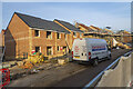
Construction of new homes at Weir Hill / Lily Hay
New Taylor Wimpey homes constructed on the edge of Shrewsbury as part of a joint construction site with Persimmon Homes. These ones are Taylor Wimpey.
Image: © Andrew Abbott
Taken: 15 Feb 2023
0.02 miles
4
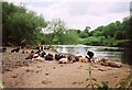
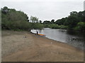
Cows on the beach
These cows seemed happy enough on the beach adjacent to the River Severn, rather than grazing in the fields to the left.
Image: © Graham Horn
Taken: 30 May 2005
0.20 miles
6

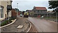
The end-of-the-road
The chapel in Shrewsbury Crematorium.
Image: © Row17
Taken: 16 Mar 2008
0.25 miles