IMAGES TAKEN NEAR TO
Shaw Road, SHREWSBURY, SY2 5RN
Introduction
This page details the photographs taken nearby to Shaw Road, SY2 5RN by members of the Geograph project.
The Geograph project started in 2005 with the aim of publishing, organising and preserving representative images for every square kilometre of Great Britain, Ireland and the Isle of Man.

There are currently over 7.5m images from over14,400 individuals and you can help contribute to the project by visiting https://www.geograph.org.uk
Image Map
Images are licensed for reuse under creativecommons.org/licenses/by-sa/2.0
Notes
- Clicking on the map will re-center to the selected point.
- The higher the marker number, the further away the image location is from the centre of the postcode.
Image Listing (13 Images Found)
Images are licensed for reuse under creativecommons.org/licenses/by-sa/2.0
Image
Details
Distance

7
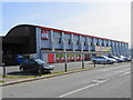
Former aircraft hangar
RAF Monkmoor was established in 1918 as a school for Air Observation and General Service Sheds built for an Aircraft Acceptance Park and Aircraft Repair Depot. Three of the four sheds built in pairs retain their original timber 'Belfast' trusses.
This pair were turned down for listing.
Image: © John M
Taken: 5 Apr 2018
0.23 miles
8
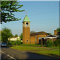
St Winefride's Church
St Winefride's Roman Catholic Church, from Crowmere Road
Image: © Andrew Bennett
Taken: 28 Apr 2007
0.23 miles

