IMAGES TAKEN NEAR TO
Elmfield Road, SHREWSBURY, SY2 5PB
Introduction
This page details the photographs taken nearby to Elmfield Road, SY2 5PB by members of the Geograph project.
The Geograph project started in 2005 with the aim of publishing, organising and preserving representative images for every square kilometre of Great Britain, Ireland and the Isle of Man.

There are currently over 7.5m images from over14,400 individuals and you can help contribute to the project by visiting https://www.geograph.org.uk
Image Map
Images are licensed for reuse under creativecommons.org/licenses/by-sa/2.0
Notes
- Clicking on the map will re-center to the selected point.
- The higher the marker number, the further away the image location is from the centre of the postcode.
Image Listing (53 Images Found)
Images are licensed for reuse under creativecommons.org/licenses/by-sa/2.0
Image
Details
Distance
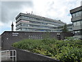
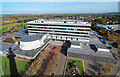
1
Magistrates' Court, Shrewsbury
The foreground shadow is from the Shirehall building.http://www.geograph.org.uk/photo/1422259
Image: © Dave Croker
Taken: 25 Sep 2009
0.07 miles
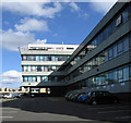
2
Front of the Magistrates' Court, Shrewsbury
Image: © Dave Croker
Taken: 30 Jul 2009
0.09 miles

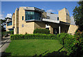
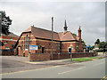
5
Part of the Shire Hall, Shrewsbury
A building that yells "Im from the 1960s or 1970's! Look at my flat roof!"
Image: © Jeremy Bolwell
Taken: 28 Jun 2020
0.15 miles
6
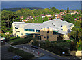
Shirehall from Lord Hill's Column
The circular concrete building in front of the office block is the council chamber.
The shadow on the left is from the column http://www.geograph.org.uk/photo/1534682
Image: © Dave Croker
Taken: 13 Oct 2009
0.16 miles

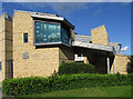
9
Shropshire Register office in Preston Street
Image: © John Firth
Taken: 26 Jul 2010
0.18 miles
10
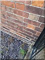
Ordnance Survey Cut Mark
This OS cut mark can be found on No4 Preston Street. It marks a point 67.940m above mean sea level.
Image: © Adrian Dust
Taken: 4 Jul 2023
0.18 miles