IMAGES TAKEN NEAR TO
Frensham Road, SHREWSBURY, SY2 5ND
Introduction
This page details the photographs taken nearby to Frensham Road, SY2 5ND by members of the Geograph project.
The Geograph project started in 2005 with the aim of publishing, organising and preserving representative images for every square kilometre of Great Britain, Ireland and the Isle of Man.

There are currently over 7.5m images from over14,400 individuals and you can help contribute to the project by visiting https://www.geograph.org.uk
Image Map
Images are licensed for reuse under creativecommons.org/licenses/by-sa/2.0
Notes
- Clicking on the map will re-center to the selected point.
- The higher the marker number, the further away the image location is from the centre of the postcode.
Image Listing (21 Images Found)
Images are licensed for reuse under creativecommons.org/licenses/by-sa/2.0
Image
Details
Distance
1
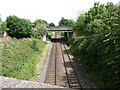
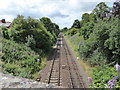
The railway line in Cherry Orchard, Shrewsbury
Hmmm. Looking eastwards.
Image: © Jeremy Bolwell
Taken: 28 Jun 2020
0.17 miles
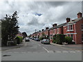
2
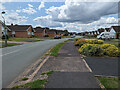
Bungalows on Portland Crescent
Imagine living somewhere where every house looked the same, with no street trees (or front garden trees for that matter) whatsoever, very few shrubs, hardly any flowers, but lots of plain, green grass. Here, ladies and gentleman, is Portland Crescent...
Image: © TCExplorer
Taken: 29 Jun 2023
0.18 miles
3
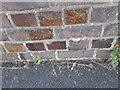
Ordnance Survey Cut Mark
This OS cut mark can be found on the SE parapet of the Sparrow Lane railway bridge. It marks a point 64.523m above mean sea level.
Image: © Adrian Dust
Taken: 4 Jul 2023
0.18 miles
5
Railway line in Cherry Orchard, Shrewsbury
Looking townward.
Image: © Jeremy Bolwell
Taken: 28 Jun 2020
0.19 miles
6
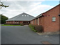
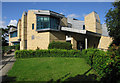
Shrewsbury Baptist Church
A relatively new church in the Crowmoor area of Shrewsbury
Image: © Richard Law
Taken: 26 Sep 2015
0.19 miles
8
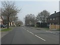
Bishop Street, Cherry Orchard, Shrewsbury
Bunting flies here.
Image: © Jeremy Bolwell
Taken: 28 Jun 2020
0.20 miles
9
Ordnance Survey Cut Mark
This OS cut mark can be found on No44 Bishop Street. It marks a point 63.177m above mean sea level.
Image: © Adrian Dust
Taken: 4 Jul 2023
0.20 miles
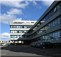
10
Front of the Magistrates' Court, Shrewsbury
Image: © Dave Croker
Taken: 30 Jul 2009
0.20 miles