IMAGES TAKEN NEAR TO
Crowmere Road, SHREWSBURY, SY2 5LE
Introduction
This page details the photographs taken nearby to Crowmere Road, SY2 5LE by members of the Geograph project.
The Geograph project started in 2005 with the aim of publishing, organising and preserving representative images for every square kilometre of Great Britain, Ireland and the Isle of Man.

There are currently over 7.5m images from over14,400 individuals and you can help contribute to the project by visiting https://www.geograph.org.uk
Image Map
Images are licensed for reuse under creativecommons.org/licenses/by-sa/2.0
Notes
- Clicking on the map will re-center to the selected point.
- The higher the marker number, the further away the image location is from the centre of the postcode.
Image Listing (9 Images Found)
Images are licensed for reuse under creativecommons.org/licenses/by-sa/2.0
Image
Details
Distance
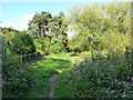
3
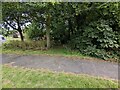
Start of footpath to the River Severn
This clearance through the trees takes one down to the footpath alongside the River Severn
Image: © TCExplorer
Taken: 29 Jun 2023
0.19 miles
4
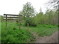
Monkmoor Community Woodland
One of those little community spaces which are so valuable.
Image: © Jeremy Bolwell
Taken: 4 May 2012
0.20 miles
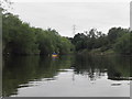
5
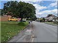
Severn Way east of Belvidere
The Severn Way between the houses in Belvidere on the eastern side of Shrewsbury, and the river itself just behind the trees on the right.
Image: © Richard Law
Taken: 26 Sep 2015
0.22 miles
9
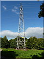
Pylon and power line at Monkmoor
Fed from Image, this line runs power into the eastern side of Shrewsbury.
Image: © Richard Law
Taken: 26 Sep 2015
0.23 miles