IMAGES TAKEN NEAR TO
Barleyfield, SHREWSBURY, SY2 5JX
Introduction
This page details the photographs taken nearby to Barleyfield, SY2 5JX by members of the Geograph project.
The Geograph project started in 2005 with the aim of publishing, organising and preserving representative images for every square kilometre of Great Britain, Ireland and the Isle of Man.

There are currently over 7.5m images from over14,400 individuals and you can help contribute to the project by visiting https://www.geograph.org.uk
Image Map
Images are licensed for reuse under creativecommons.org/licenses/by-sa/2.0
Notes
- Clicking on the map will re-center to the selected point.
- The higher the marker number, the further away the image location is from the centre of the postcode.
Image Listing (19 Images Found)
Images are licensed for reuse under creativecommons.org/licenses/by-sa/2.0
Image
Details
Distance
1
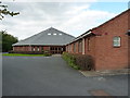
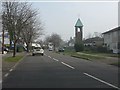
Shrewsbury Baptist Church
A relatively new church in the Crowmoor area of Shrewsbury
Image: © Richard Law
Taken: 26 Sep 2015
0.08 miles
8
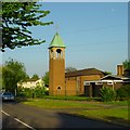
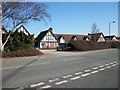
St Winefride's Church
St Winefride's Roman Catholic Church, from Crowmere Road
Image: © Andrew Bennett
Taken: 28 Apr 2007
0.21 miles
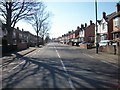
9
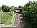
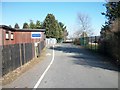
The railway line in Cherry Orchard, Shrewsbury
Hmmm. Looking eastwards.
Image: © Jeremy Bolwell
Taken: 28 Jun 2020
0.21 miles
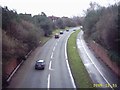
10
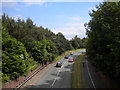
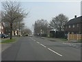
A5112 Robertson Way, Monkmoor
Part of what could be described as Shrewsbury's inner bypass, seen from Monkmoor Road under which it passes. This road has been superseded for through traffic by the current alignments of the A49 and A5, which skirt the edge of Shrewsbury rather than passing through its suburbs.
Image: © Richard Vince
Taken: 19 Jun 2015
0.22 miles