IMAGES TAKEN NEAR TO
Alfred Street, SHREWSBURY, SY2 5EY
Introduction
This page details the photographs taken nearby to Alfred Street, SY2 5EY by members of the Geograph project.
The Geograph project started in 2005 with the aim of publishing, organising and preserving representative images for every square kilometre of Great Britain, Ireland and the Isle of Man.

There are currently over 7.5m images from over14,400 individuals and you can help contribute to the project by visiting https://www.geograph.org.uk
Image Map
Images are licensed for reuse under creativecommons.org/licenses/by-sa/2.0
Notes
- Clicking on the map will re-center to the selected point.
- The higher the marker number, the further away the image location is from the centre of the postcode.
Image Listing (131 Images Found)
Images are licensed for reuse under creativecommons.org/licenses/by-sa/2.0
Image
Details
Distance
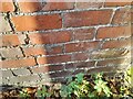
2
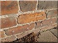
OS benchmark - Shrewsbury, 1 Sunnyfields
An OS cutmark on the wall of no 1 Sunnyfields, which was last levelled in 1967 at 63.478m above Ordnance Datum Newlyn. It also appears on the 1901 map at 208.5ft Liverpool datum.
Image: © Richard Law
Taken: 27 Aug 2023
0.06 miles
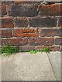
3
Ordnance Survey Cut Mark
This OS cut mark can be found on No17B Clifford Street. It marks a point 63.633m above mean sea level.
Image: © Adrian Dust
Taken: 4 Jul 2023
0.07 miles
4
OS benchmark - Shrewsbury, 17B Clifford Street
An OS cutmark in the wall on the south side of the passageway which runs between Clifford St and Monkmoor Road, which was last levelled by the OS in 1951 at 63.633m above Ordnance Datum Newlyn. It appears on the 1901 map at 207.5ft Liverpool Datum.
Image: © Richard Law
Taken: 27 Aug 2023
0.07 miles
5
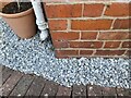
Ordnance Survey Cut Mark
This OS cut mark can be found on No1 Sunnyfields. It marks a point 63.478m above mean sea level.
Image: © Adrian Dust
Taken: 4 Jul 2023
0.07 miles
6
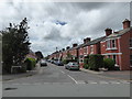
Bishop Street, Cherry Orchard, Shrewsbury
Bunting flies here.
Image: © Jeremy Bolwell
Taken: 28 Jun 2020
0.08 miles
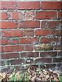
7
Ordnance Survey Cut Mark
This OS cut mark can be found on No44 Bishop Street. It marks a point 63.177m above mean sea level.
Image: © Adrian Dust
Taken: 4 Jul 2023
0.08 miles
8
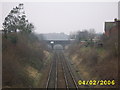
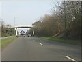
Railway Line And Bridge
This is the line between Shrewsbury and Birmingham
Image: © Mr M Evison
Taken: 4 Feb 2006
0.10 miles
9
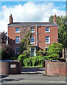
108 Abbey Foregate, Shrewsbury
Dated c1840, although it could pass for late Georgian. Pretty lattice-work wrought-iron porch. Grade II listed.
Since the photo, when it was offices of Buntings, architects, it appears to have been converted back to a private house.
Image: © Stephen Richards
Taken: 12 May 2014
0.12 miles
10
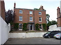
108 Abbey Foregate, Shrewsbury
Set a little way back from the road, and now with space for a carpark at the front, no 108 dates from around 1840 and was Grade II listed https://britishlistedbuildings.co.uk/101246362-108-abbey-foregate-shrewsbury#.XWLyLOhKjcs & https://historicengland.org.uk/listing/the-list/list-entry/1246362 in 1953.
Image: © Richard Law
Taken: 4 Jul 2019
0.12 miles