IMAGES TAKEN NEAR TO
Sparrow Lane, SHREWSBURY, SY2 5EP
Introduction
This page details the photographs taken nearby to Sparrow Lane, SY2 5EP by members of the Geograph project.
The Geograph project started in 2005 with the aim of publishing, organising and preserving representative images for every square kilometre of Great Britain, Ireland and the Isle of Man.

There are currently over 7.5m images from over14,400 individuals and you can help contribute to the project by visiting https://www.geograph.org.uk
Image Map
Images are licensed for reuse under creativecommons.org/licenses/by-sa/2.0
Notes
- Clicking on the map will re-center to the selected point.
- The higher the marker number, the further away the image location is from the centre of the postcode.
Image Listing (137 Images Found)
Images are licensed for reuse under creativecommons.org/licenses/by-sa/2.0
Image
Details
Distance
1
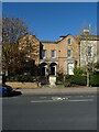
119 & 120 Abbey Foregate, Shrewsbury
This pair of mirrored houses was built around 1840, and attracted its Grade II listing https://britishlistedbuildings.co.uk/101246379-119-and-120-abbey-foregate-shrewsbury & https://historicengland.org.uk/listing/the-list/list-entry/1246379 in 1953.
Image: © Richard Law
Taken: 20 Apr 2023
0.04 miles
2
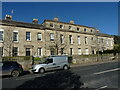
121 - 124 Abbey Foregate, Shrewsbury
A row of substantial, early 19th century houses, built around 1820. The terrace was Grade II listed in 1953, along with the garden wall, gatepiers and balustraded fencing which abuts the footway https://britishlistedbuildings.co.uk/101246326-121-124-abbey-foregate-and-garden-walls-shrewsbury & https://historicengland.org.uk/listing/the-list/list-entry/1246326.
Image: © Richard Law
Taken: 20 Apr 2023
0.04 miles
3
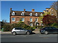
116, 117 & 118 Abbey Foregate, Shrewsbury
Originally built as a pair, but later converted to three houses. The external appearance is of the mid 18th century, although they are thought to have an older core - there are other buildings nearby of 17th century origin. The terrace was Grade II listed https://britishlistedbuildings.co.uk/101271424-116-117-118-abbey-foregate-shrewsbury & https://historicengland.org.uk/listing/the-list/list-entry/1271424 in two phases in 1969 & 1973, respectively.
Image: © Richard Law
Taken: 20 Apr 2023
0.04 miles
4
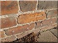
Ordnance Survey Cut Mark
This OS cut mark can be found on No1 Sunnyfields. It marks a point 63.478m above mean sea level.
Image: © Adrian Dust
Taken: 4 Jul 2023
0.05 miles
5
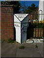
Milepost on the A5 near Bells Lane
A cast-iron milepost, possibly moved a few yards to the SE from its original position when the bridge over Bage Way was built. It dates from the early 19th century, was erected by the local turnpike organisation (the Watling Street, Shrewsbury District & Branch), and was Grade II listed https://britishlistedbuildings.co.uk/101271366-mile-post-at-junction-with-bell-lane-shrewsbury & https://historicengland.org.uk/listing/the-list/list-entry/1271366?section=official-list-entry in 1995.
Image: © Richard Law
Taken: 20 Apr 2023
0.05 miles
6
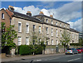
121-124 Abbey Foregate, Shrewsbury
A severe early C19th group in Grinshill stone, its discipline undermined by subsequent lowering of some of the first-floor windows. Good wall with pierced balustrade in front. Grade II listed.
Image: © Stephen Richards
Taken: 12 May 2014
0.05 miles
7

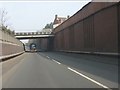
Abbey Foregate bridging the A5112 Bage Way
An old cast iron milestone to the right
Image: © Martin Dawes
Taken: 1 Jun 2009
0.05 miles
8
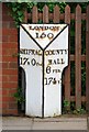
Old Milepost by Abbey Foregate, Shrewsbury
Cast iron post by the UC road (was A5), in parish of SHREWSBURY (SHREWSBURY AND ATCHAM District), Abbey Foregate, Shrewsbury, just South of the junction with Bell Lane, on pavement against fence of No. 116, on Northeast side of road. Erected by the Watling Street, Shrewsbury District & Branch turnpike trust in the 19th century.
Inscription reads:-
: SHIFNAL / 17M 0FUR : : LONDON / 150 : : COUNTY / HALL / 6 FUR. / 174Yˢ. :
Grade II listed.
List Entry Number: 1271366 https://historicengland.org.uk/listing/the-list/list-entry/1271366
Milestone Society National ID: SA_SFSB17.
Image: © A Reade/M Faherty
Taken: 10 Feb 2008
0.05 miles
9
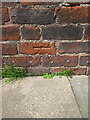
OS benchmark - Shrewsbury, 1 Sunnyfields
An OS cutmark on the wall of no 1 Sunnyfields, which was last levelled in 1967 at 63.478m above Ordnance Datum Newlyn. It also appears on the 1901 map at 208.5ft Liverpool datum.
Image: © Richard Law
Taken: 27 Aug 2023
0.05 miles