IMAGES TAKEN NEAR TO
Ashley Street, SHREWSBURY, SY2 5DU
Introduction
This page details the photographs taken nearby to Ashley Street, SY2 5DU by members of the Geograph project.
The Geograph project started in 2005 with the aim of publishing, organising and preserving representative images for every square kilometre of Great Britain, Ireland and the Isle of Man.

There are currently over 7.5m images from over14,400 individuals and you can help contribute to the project by visiting https://www.geograph.org.uk
Image Map
Images are licensed for reuse under creativecommons.org/licenses/by-sa/2.0
Notes
- Clicking on the map will re-center to the selected point.
- The higher the marker number, the further away the image location is from the centre of the postcode.
Image Listing (105 Images Found)
Images are licensed for reuse under creativecommons.org/licenses/by-sa/2.0
Image
Details
Distance
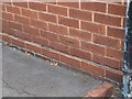
1
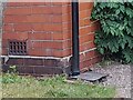
Ordnance Survey Cut Mark
This OS cut mark can be found on No58 Underdale Road. It marks a point 60.113m above mean sea level.
Image: © Adrian Dust
Taken: 4 Jul 2023
0.05 miles
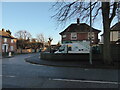
2
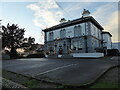
The Abbey, Monkmoor, Shrewsbury
Classy looking place. Well tended, maintained and presented.
Image: © Jeremy Bolwell
Taken: 2 Jan 2021
0.06 miles
3
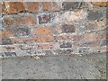
Ordnance Survey Cut Mark
This OS cut mark can be found on the wall of Stoneleigh, Bradford Road. It marks a point 60.987m above mean sea level.
Image: © Adrian Dust
Taken: 4 Jul 2023
0.07 miles
4
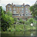
44 - 49 (odds) Underdale Road, Shrewsbury
Only mildly impressive from the other side on Underdale Road. From this side, although the architecture is perhaps less pretty, the location is splendid.
Image: © Robin Webster
Taken: 27 Sep 1990
0.08 miles
5
A street corner in Monkmoor, Shrewsbury
Heritage Glass Group have premises here.
Image: © Jeremy Bolwell
Taken: 2 Jan 2021
0.09 miles
6
Ordnance Survey Cut Mark
This OS cut mark can be found on No79 Monkmoor Road. It marks a point 63.002m above mean sea level.
Image: © Adrian Dust
Taken: 4 Jul 2023
0.09 miles
7
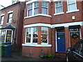
69, Monkmoor Road, Monkmoor, Shrewsbury with its blue plaque for Wilfred Owen
Wilfred Owen moved here with his family when he was 17 years of age and wrote some of his early poems here. The famous blue plaque system commemorates this.
It must be somewhat a pain for the current residents who are, I am sure, just trying to occupy their home normally when people like me rock up and snap away...
I am hopeful that like me, they have been moved by his poems and can understand. Owen was perhaps the greatest poet of the Great War...
Shrewsbury does not have many blue plaques.
Image: © Jeremy Bolwell
Taken: 2 Jan 2021
0.10 miles
8

Sydney Avenue, Shrewsbury
A treelined avenue beside the river.
Image: © Jeremy Bolwell
Taken: 2 Jan 2021
0.12 miles
9
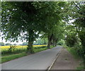
Tree-lined Sydney Avenue, Shrewsbury
On a bank of the River Severn, Sydney Avenue is part of National
Cycle Network Route 81 from Shrewsbury to Wellington (Shropshire).
Image: © Jaggery
Taken: 31 May 2014
0.12 miles
10
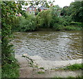
River Severn access steps, Sydney Avenue, Shrewsbury
The choppy water has been created by the Severn tumbling down this weir. http://www.geograph.org.uk/photo/4548421
Image: © Jaggery
Taken: 31 May 2014
0.12 miles