IMAGES TAKEN NEAR TO
Llangeitho, TREGARON, SY25 6SY
Introduction
This page details the photographs taken nearby to SY25 6SY by members of the Geograph project.
The Geograph project started in 2005 with the aim of publishing, organising and preserving representative images for every square kilometre of Great Britain, Ireland and the Isle of Man.

There are currently over 7.5m images from over14,400 individuals and you can help contribute to the project by visiting https://www.geograph.org.uk
Image Map
Images are licensed for reuse under creativecommons.org/licenses/by-sa/2.0
Notes
- Clicking on the map will re-center to the selected point.
- The higher the marker number, the further away the image location is from the centre of the postcode.
Image Listing (5 Images Found)
Images are licensed for reuse under creativecommons.org/licenses/by-sa/2.0
Image
Details
Distance
1
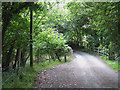
Lane crossing Nant Meidrum, Ceredigion
The bridge over the stream is where the lane narrows.
Image: © Roger D Kidd
Taken: 15 Jul 2008
0.19 miles
2
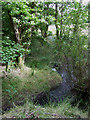
Nant Meidrum near Llangeitho, Ceredigion
Image: © Roger D Kidd
Taken: 15 Jul 2008
0.20 miles
3
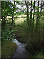
Nant Meidrum near Llangeitho, Ceredigion
The upper part of the brook flows towards the camera here, on its way towards the Afon Aeron which it joins just south-west of Llangeitho.
Image: © Roger D Kidd
Taken: 15 Jul 2008
0.21 miles
4
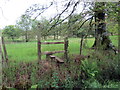
Sticil ger Nant Meidrum / Stile near Nant Meidrum
Llwybr ger Nant Meidrum.
A path near Nant Meidrum (trans. middle ridge stream).
Image: © Alan Richards
Taken: 12 Jun 2019
0.23 miles
5
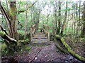
Pompren Nant Meidrum / Nant Meidrum Footbridge
Pompren yn rhychwantu Nant Meidrum.
A footbridge spanning Nant Meidrum (trans. middle ridge stream).
Image: © Alan Richards
Taken: 12 Jun 2019
0.23 miles