IMAGES TAKEN NEAR TO
Penuwch, TREGARON, SY25 6RF
Introduction
This page details the photographs taken nearby to SY25 6RF by members of the Geograph project.
The Geograph project started in 2005 with the aim of publishing, organising and preserving representative images for every square kilometre of Great Britain, Ireland and the Isle of Man.

There are currently over 7.5m images from over14,400 individuals and you can help contribute to the project by visiting https://www.geograph.org.uk
Image Map
Images are licensed for reuse under creativecommons.org/licenses/by-sa/2.0
Notes
- Clicking on the map will re-center to the selected point.
- The higher the marker number, the further away the image location is from the centre of the postcode.
Image Listing (5 Images Found)
Images are licensed for reuse under creativecommons.org/licenses/by-sa/2.0
Image
Details
Distance
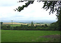
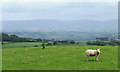
2
Pasture south of Penuwch, Ceredigion
The area is devoted almost exclusively to grass for winter feed and summer pasture; sheep and cattle (often Welsh Blacks).
Image: © Roger D Kidd
Taken: 16 Jul 2008
0.07 miles
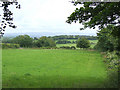
3
Ceredigion farmland south of Penuwch
Looking across the Aeron and Teifi valleys towards the Elenydd hills.
Image: © Roger D Kidd
Taken: 16 Jul 2008
0.09 miles
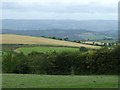
4
Ceredigion Landscape towards the Aeron Valley
The terrain undulates southwards towards the Aeron and Teifi valleys and the Elenydd.
Image: © Roger D Kidd
Taken: 16 Jul 2008
0.18 miles
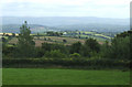
5
Grazing near Penuwch, Ceredigion
The distant hills of the Elenydd are beyond the Aeron and Teifi valleys.
Image: © Roger D Kidd
Taken: 16 Jul 2008
0.23 miles