IMAGES TAKEN NEAR TO
Penuwch, TREGARON, SY25 6QZ
Introduction
This page details the photographs taken nearby to SY25 6QZ by members of the Geograph project.
The Geograph project started in 2005 with the aim of publishing, organising and preserving representative images for every square kilometre of Great Britain, Ireland and the Isle of Man.

There are currently over 7.5m images from over14,400 individuals and you can help contribute to the project by visiting https://www.geograph.org.uk
Image Map
Images are licensed for reuse under creativecommons.org/licenses/by-sa/2.0
Notes
- Clicking on the map will re-center to the selected point.
- The higher the marker number, the further away the image location is from the centre of the postcode.
Image Listing (6 Images Found)
Images are licensed for reuse under creativecommons.org/licenses/by-sa/2.0
Image
Details
Distance
1
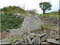
Disused small quarry face, Penuwch, Ceredigion
The workings are not extensive. The pit at the base of the slabs is flooded (I didn't test the depth!) and the grass is tussocky between some of the stones in the foreground, and boggy.
Image: © Roger D Kidd
Taken: 16 Jul 2008
0.19 miles
2
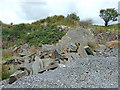
Disused quarry, Penuwch, ceredigion
The slate workings are not extensive, and there is boggy land between rocks, and a pool by the main slabs shown here
Image: © Roger D Kidd
Taken: 16 Jul 2008
0.20 miles
3
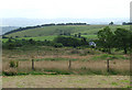
Penuwch farmland, Ceredigion
This is the view south from the beer garden of the Penuwch Inn.
Image: © Roger D Kidd
Taken: 16 Jul 2008
0.21 miles
4
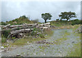
Timber by disused quarry track, Penuwch, Ceredigion
Image: © Roger D Kidd
Taken: 16 Jul 2008
0.21 miles
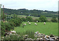
5
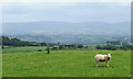
Grazing near Penuwch, Ceredigion
The distant hills of the Elenydd are beyond the Aeron and Teifi valleys.
Image: © Roger D Kidd
Taken: 16 Jul 2008
0.23 miles