IMAGES TAKEN NEAR TO
Llangeitho, TREGARON, SY25 6QU
Introduction
This page details the photographs taken nearby to SY25 6QU by members of the Geograph project.
The Geograph project started in 2005 with the aim of publishing, organising and preserving representative images for every square kilometre of Great Britain, Ireland and the Isle of Man.

There are currently over 7.5m images from over14,400 individuals and you can help contribute to the project by visiting https://www.geograph.org.uk
Image Map
Images are licensed for reuse under creativecommons.org/licenses/by-sa/2.0
Notes
- Clicking on the map will re-center to the selected point.
- The higher the marker number, the further away the image location is from the centre of the postcode.
Image Listing (9 Images Found)
Images are licensed for reuse under creativecommons.org/licenses/by-sa/2.0
Image
Details
Distance
1
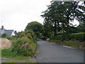
B4342 i Langeitho / B4342 to Llangeitho
B4342 yn Stag's Head ger Llangeitho / B4342 in Stag's Head near Llangeitho.
Image: © Ian Medcalf
Taken: 23 Jun 2007
0.02 miles
2
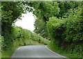
B4342 to Llangeitho, at Stags Head, Ceredigion
The B4342 goes from Tregaron to New Quay via Llangeitho. Here it is climbing from the Stags Head crossroads.
Image: © Roger D Kidd
Taken: 19 Jul 2011
0.02 miles
3
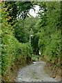
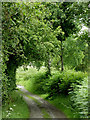
Farm track west of Stags Head, Ceredigion
The track is also used as a public footpath to Llangeitho which crosses the fields on Birch Hill and emerges by the chapel.
Image: © Roger D Kidd
Taken: 19 Jul 2011
0.05 miles
4
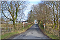
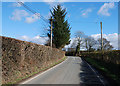
Western approach to Stag's Head
The B4342 from Llangeitho carries a fair amount of traffic, but contains a lot of narrow stretches, like this bit entering Stag's Head.
Image: © Nigel Brown
Taken: 15 Feb 2013
0.07 miles
5
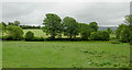
Farmland west of Stag's Head, Ceredigion
Most fields in the area are under grass for sheep and cattle.
Image: © Roger D Kidd
Taken: 19 Jul 2011
0.15 miles
6
The B4342 near Derlwyn
The road east of Llangeitho narrows for a bit; here it is about to widen into a proper double-track road.
Image: © Nigel Brown
Taken: 4 Mar 2008
0.17 miles
7
Farmland west of Stags Head, Ceredigion
Grass is being cut for hay so the sheep and/or cattle will be on this land soon.
Image: © Roger D Kidd
Taken: 19 Jul 2011
0.17 miles
8
Farm track west of Stags Head, Ceredigion
The track leads to fields both sides of the infant Nant y Maen. The track may possibly have reached as far as Sarn Helen near SN63455891.
Image: © Roger D Kidd
Taken: 19 Jul 2011
0.17 miles
9
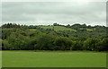
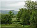
Pasture and woodland south-west of Stags Head, Ceredigion
On the skyline is Cefncoed with a summit height of 231 metres (781 feet).
Image: © Roger D Kidd
Taken: 19 Jul 2011
0.24 miles