IMAGES TAKEN NEAR TO
Llangeitho, TREGARON, SY25 6QJ
Introduction
This page details the photographs taken nearby to SY25 6QJ by members of the Geograph project.
The Geograph project started in 2005 with the aim of publishing, organising and preserving representative images for every square kilometre of Great Britain, Ireland and the Isle of Man.

There are currently over 7.5m images from over14,400 individuals and you can help contribute to the project by visiting https://www.geograph.org.uk
Image Map
Images are licensed for reuse under creativecommons.org/licenses/by-sa/2.0
Notes
- Clicking on the map will re-center to the selected point.
- The higher the marker number, the further away the image location is from the centre of the postcode.
Image Listing (1 Images Found)
Images are licensed for reuse under creativecommons.org/licenses/by-sa/2.0
Image
Details
Distance
1
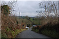
Steep hill on the road near Ffynnon-Geitho Isaf
The road is parallel to the Nant Ffynnon Geitho as both head down the hill, en route to Llangeitho.
Image: © Nigel Brown
Taken: 13 Jan 2009
0.13 miles