IMAGES TAKEN NEAR TO
Llwynygroes, TREGARON, SY25 6QA
Introduction
This page details the photographs taken nearby to SY25 6QA by members of the Geograph project.
The Geograph project started in 2005 with the aim of publishing, organising and preserving representative images for every square kilometre of Great Britain, Ireland and the Isle of Man.

There are currently over 7.5m images from over14,400 individuals and you can help contribute to the project by visiting https://www.geograph.org.uk
Image Map
Images are licensed for reuse under creativecommons.org/licenses/by-sa/2.0
Notes
- Clicking on the map will re-center to the selected point.
- The higher the marker number, the further away the image location is from the centre of the postcode.
Image Listing (10 Images Found)
Images are licensed for reuse under creativecommons.org/licenses/by-sa/2.0
Image
Details
Distance
1
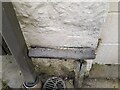
Ordnance Survey Cut Mark
This OS cut mark can be found on the NE angle of the chapel. It marks a point 175.647m above mean sea level.
Image: © Adrian Dust
Taken: 20 Feb 2023
0.00 miles
2
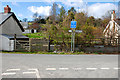
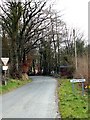
Road junction, Llwyn-y-groes
Where the lane from Olmarch meets the road between Llangeitho and Lampeter.
Image: © Nigel Brown
Taken: 5 Apr 2008
0.04 miles
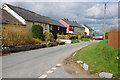
4
Lane approaching Llwyn-y-Groes, Ceredigion
This is the lane entering the village from the south.
Image: © Roger D Kidd
Taken: 20 Jul 2011
0.11 miles
5
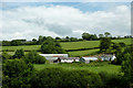
Pant-y-rhew farm at Llwyn-y-Groes, Ceredigion
Seen from the lane near Jane Beck's Welsh Blankets Emporium; she gave me some very suspicious looks as I took the photographs!
Image: © Roger D Kidd
Taken: 20 Jul 2011
0.12 miles
6
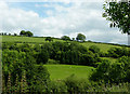
Farmland south of Llwyn-y-Groes, Ceredigion
The fields are all around Pant-y-rhew farm, which is off to the left. This is a view seen from the lane while being "observed" by Jane Beck in her Welsh Blanket Emporium garden.
Image: © Roger D Kidd
Taken: 20 Jul 2011
0.13 miles
7
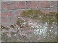
Ordnance Survey Cut Mark
This OS cut mark can be found on the churn stand NW side of the road. It marks a point 169.411m above mean sea level. https://www.geograph.org.uk/photo/7412363
Image: © Adrian Dust
Taken: 20 Feb 2023
0.18 miles
8
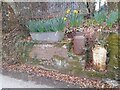
Churn Stand
There is an Ordnance Survey cut mark on the front of the stand. https://www.geograph.org.uk/photo/7412358
Image: © Adrian Dust
Taken: 20 Feb 2023
0.18 miles
9
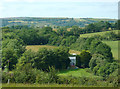
Farmland north of Llwyn-y-Groes, Ceredigion
The farm buildings at Bron Haul are well sheltered among mature deciduous trees. The distant hill line marks the northern slopes of Dyffryn Aeron.
Image: © Roger D Kidd
Taken: 20 Jul 2011
0.21 miles
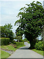
10
Approaching Llwyn-y-groes from Gartheli
Image: © John Fielding
Taken: 31 Mar 2008
0.24 miles