IMAGES TAKEN NEAR TO
TREGARON, SY25 6PR
Introduction
This page details the photographs taken nearby to SY25 6PR by members of the Geograph project.
The Geograph project started in 2005 with the aim of publishing, organising and preserving representative images for every square kilometre of Great Britain, Ireland and the Isle of Man.

There are currently over 7.5m images from over14,400 individuals and you can help contribute to the project by visiting https://www.geograph.org.uk
Image Map
Images are licensed for reuse under creativecommons.org/licenses/by-sa/2.0
Notes
- Clicking on the map will re-center to the selected point.
- The higher the marker number, the further away the image location is from the centre of the postcode.
Image Listing (5 Images Found)
Images are licensed for reuse under creativecommons.org/licenses/by-sa/2.0
Image
Details
Distance
2
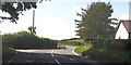
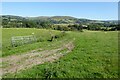
Grazing Land and Teifi Valley, Llanio, Ceredigion
Image: © Roger Kidd
Taken: 28 Jul 2007
0.12 miles
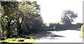
4
Road junction at Trocelyn
Trocelyn is the house on the right
Image: © John Firth
Taken: 5 Sep 2012
0.18 miles
5
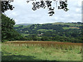
The Teifi Valley
View across the Teifi valley near Pont Llanio. Bryn Rhudd is the hill on the far side of the valley.
Image: © Philip Halling
Taken: 15 Jul 2021
0.21 miles