IMAGES TAKEN NEAR TO
TREGARON, SY25 6NH
Introduction
This page details the photographs taken nearby to SY25 6NH by members of the Geograph project.
The Geograph project started in 2005 with the aim of publishing, organising and preserving representative images for every square kilometre of Great Britain, Ireland and the Isle of Man.

There are currently over 7.5m images from over14,400 individuals and you can help contribute to the project by visiting https://www.geograph.org.uk
Image Map
Images are licensed for reuse under creativecommons.org/licenses/by-sa/2.0
Notes
- Clicking on the map will re-center to the selected point.
- The higher the marker number, the further away the image location is from the centre of the postcode.
Image Listing (5 Images Found)
Images are licensed for reuse under creativecommons.org/licenses/by-sa/2.0
Image
Details
Distance
1
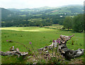
Farmland south-east of Tregaron, Ceredigion
The valley of the Afon Groes is straight ahead beyond the sunlit part of the pasture.
Image: © Roger D Kidd
Taken: 26 Jul 2008
0.18 miles
2
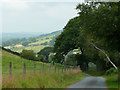
Narrow Lane approaching Tregaron, Ceredigion
Image: © Roger D Kidd
Taken: 26 Jul 2008
0.18 miles
3
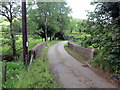
Pont dros Nant y Fleinog / Bridge over Nant y Fleinog
Pont yn rhychwantu Nant y Fleinog.
A bridge spanning Nant y Fleinog stream.
Image: © Alan Richards
Taken: 26 Jun 2019
0.19 miles
4
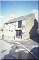
Warehouse at Tregaron
Just off the main square, by the road leading to Abergwesyn
Image: © Andrew Longton
Taken: 27 Jun 2004
0.20 miles
5
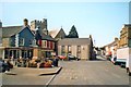
Tregaron Market Place
The centre of what is possibly the quietest town in Wales.
Image: © Gordon Hatton
Taken: Unknown
0.20 miles