IMAGES TAKEN NEAR TO
TREGARON, SY25 6NG
Introduction
This page details the photographs taken nearby to SY25 6NG by members of the Geograph project.
The Geograph project started in 2005 with the aim of publishing, organising and preserving representative images for every square kilometre of Great Britain, Ireland and the Isle of Man.

There are currently over 7.5m images from over14,400 individuals and you can help contribute to the project by visiting https://www.geograph.org.uk
Image Map
Images are licensed for reuse under creativecommons.org/licenses/by-sa/2.0
Notes
- Clicking on the map will re-center to the selected point.
- The higher the marker number, the further away the image location is from the centre of the postcode.
Image Listing (7 Images Found)
Images are licensed for reuse under creativecommons.org/licenses/by-sa/2.0
Image
Details
Distance
1
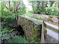
Pont dros Afon Berwyn / A bridge over Afon Berwyn
Pont yn rhychwantu Afon Berwyn.
A bridge spanning Afon Berwyn.
Image: © Alan Richards
Taken: 26 Jun 2019
0.13 miles
2

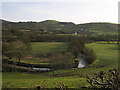
Teifi Valley and Tregaron, Ceredigion
A fine landscape from the Abergwesyn mountain road, using a telephoto lens.
Image: © Roger D Kidd
Taken: 21 Jul 2008
0.14 miles
3
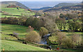
Afon Brennig
Pastures frame the river near this bend on the outskirts of Tregaron.
Image: © Rudi Winter
Taken: 15 Mar 2009
0.15 miles
4
The Afon Brennig above Aberdwr
Wending its way along the flat floor of the valley. The river has its source, as the Afon Berwyn, above Cwm Berwyn seen in the distance. For a closeup of the horses see Image
Image: © Nigel Brown
Taken: 17 Nov 2009
0.18 miles
5

Horses by the Afon Brennig
Grazing the steep pasture on this side of the river.
Image: © Nigel Brown
Taken: 17 Nov 2009
0.19 miles
6
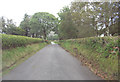
Abergwesyn mountain road near Tregaron
Just up ahead on the left is Lletty-Meurig and its red phone box.
Image: © Stuart Logan
Taken: 6 Oct 2011
0.24 miles
7
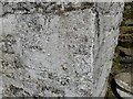
Ordnance Survey Cut Mark
This OS cut mark can be found on Lletty-meurig. It marks a point 205.398m above mean sea level.
Image: © Adrian Dust
Taken: 13 Apr 2023
0.25 miles