IMAGES TAKEN NEAR TO
Tynreithyn, TREGARON, SY25 6LT
Introduction
This page details the photographs taken nearby to SY25 6LT by members of the Geograph project.
The Geograph project started in 2005 with the aim of publishing, organising and preserving representative images for every square kilometre of Great Britain, Ireland and the Isle of Man.

There are currently over 7.5m images from over14,400 individuals and you can help contribute to the project by visiting https://www.geograph.org.uk
Image Map
Images are licensed for reuse under creativecommons.org/licenses/by-sa/2.0
Notes
- Clicking on the map will re-center to the selected point.
- The higher the marker number, the further away the image location is from the centre of the postcode.
Image Listing (2 Images Found)
Images are licensed for reuse under creativecommons.org/licenses/by-sa/2.0
Image
Details
Distance
1
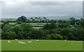
Grazing north of Tyncelyn, Ceredigion
There were sheep and cattle grazing in this field. In the distance are the Elenydd hills and moorlands beyond Tregaron and Pontrhydfendigaid.
Image: © Roger D Kidd
Taken: 21 Jul 2010
0.15 miles
2
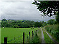
Farm track north of Tyncelyn, Ceredigion
The Elenydd moorland plateau east of Tregaron looms on the skyline.
Image: © Roger D Kidd
Taken: 21 Jul 2010
0.17 miles