IMAGES TAKEN NEAR TO
TREGARON, SY25 6LQ
Introduction
This page details the photographs taken nearby to SY25 6LQ by members of the Geograph project.
The Geograph project started in 2005 with the aim of publishing, organising and preserving representative images for every square kilometre of Great Britain, Ireland and the Isle of Man.

There are currently over 7.5m images from over14,400 individuals and you can help contribute to the project by visiting https://www.geograph.org.uk
Image Map
Images are licensed for reuse under creativecommons.org/licenses/by-sa/2.0
Notes
- Clicking on the map will re-center to the selected point.
- The higher the marker number, the further away the image location is from the centre of the postcode.
Image Listing (3 Images Found)
Images are licensed for reuse under creativecommons.org/licenses/by-sa/2.0
Image
Details
Distance
1
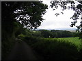
Lon Wledig / Country Lane
Lon Wledig rhwng Maesglas a Fullbook / Country Lane between Maesglas and Fullbook
Image: © Ian Medcalf
Taken: 23 Jun 2007
0.17 miles
2
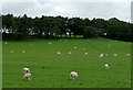
Grazing near Tynreithin, Ceredigion
Most of the farm land in this area is dedicated to the raising of sheep and cattle.
Image: © Roger D Kidd
Taken: 21 Jul 2010
0.19 miles
3
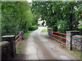
Tuag at Felin Fullbrook / Towards Fullbrook Mill
Heol yn agosau at Felin Fullbrook.
A road approaching Fullbrook Mill.
Image: © Alan Richards
Taken: 22 May 2019
0.25 miles